Madagh geodata
Madagh (Oriental) is a seat of a third-order administrative division; located in Morocco in Africa/Casablanca (GMT+1) time zone. In our database, there are 108 cities with bigger population. Compared to other cities in Morocco, 87.6% of cities are located further ↓South; 96.1% of cities are located further ←West and 82.6% of cities have higher elevation than Madagh. Note1


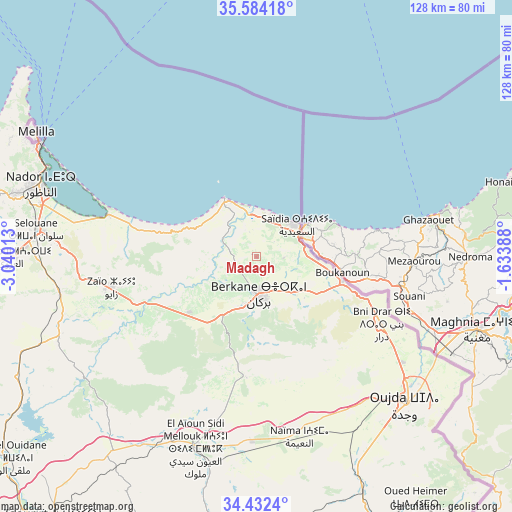
Madagh GPS coordinates[2]
35° 0' 37.152" North, 2° 20' 13.236" West
| Map corner | latitude | longitude |
|---|---|---|
| Upper-left | 35.58418°, | -3.04013° |
| Center: | 35.01032°, | -2.33701° |
| Lower-right: | 34.4324°, | -1.63388° |
| Map W x H: | 128.1×128.1 km | = 79.6×79.6mi |
| max Lat: | 35.84906° ⇑12.4% North |
| Madagh: | 35.01032° |
| min Lat: | ⇓87.6% South 22.6558° |
| min Long | Madagh | max Long |
| -15.60719° | -2.33701° | -1.22855° |
| W 96.1%⇐ | ⇒3.9% E |
Elevation
Elevation of Madagh is 76 m = 249 ft, and this is 540.8 m = 1774 ft below average elevation for this country.
| Max E: |
2637 m = 8652 ft | 82.6% |
| Avg. | 616.8 m = 2024 ft | |
| Madagh | 76 m = 249 ft | |
Min E: |
1 m = 3 ft | 17.4% |
See also: Morocco elevation on elevation.city.
Geographical zone
Madagh is located in North temperate zone (between Tropic of Cancer and the Arctic Circle). Distance of this Northern Tropic circle is 1286.9 km =799.6 mi to South.| Distance of | km | miles | from Madagh |
|---|---|---|---|
| North Pole | 6114.3 | 3799.2 | to North |
| Arctic Circle | 3508.4 | 2180 | to North |
| Tropic Cancer | 1286.9 | 799.6 | to South |
| Equator | 3892.8 | 2418.9 | to South |


Nearby cities:
15 places around Madagh: (largest is in red/bold)
• Ahfir
22.5 km =14 mi,  106°
106°
• Al Aaroui
61.2 km =38 mi,  270°
270°
• Berkane
10.2 km =6.3 mi,  171°
171°
• El Aïoun
49.9 km =31 mi,  198°
198°
• Guenfouda
64.3 km =40 mi,  155°
155°
• Hassi Berkane
51.9 km =32.2 mi,  248°
248°
• Kariat Arkmane
38.8 km =24.1 mi,  286°
286°
• Mosquée
23.7 km =14.7 mi, 196°
• Nador
57 km =35.4 mi, 287°
• Oujda-Angad
53.5 km =33.2 mi,  133°
133°
• Rislane
29 km =18 mi, 202°
• Saidia
12.7 km =7.9 mi,  50°
50°
• Selouane
55.5 km =34.5 mi,  277°
277°
• Taouima
55.4 km =34.4 mi, 283°
• Zaïo
36.8 km =22.9 mi,  258°
258°
Sources, notices
• [Note1] Compared only with cities in Morocco existing in our database
• [Src1] Map data: © OpenStreetMap contributors (CC-BY-SA)
• [Src2] Other city data from geonames.org with taken over terms of usage.
• [Src3] Geographical zone / Annual Mean Temperature by Robert A. Rohde @ Wikipedia
