Bucovăţ geodata
Bucovăţ (Strășeni) is a populated place; located in Moldova in Europe/Chisinau (GMT+3) time zone. With population of 1,600 people, there are 71 cities with bigger population in this country. Compared to other cities in Moldova, 53.4% of cities are located further ↓South; 57.5% of cities are located further →East and 65.8% of cities have lower elevation than Bucovăţ. Note1


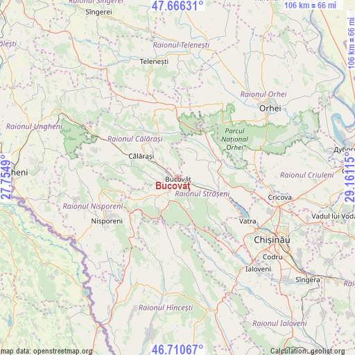
Bucovăţ GPS coordinates[2]
47° 11' 26.304" North, 28° 27' 28.872" East
| Map corner | latitude | longitude |
|---|---|---|
| Upper-left | 47.66631°, | 27.7549° |
| Center: | 47.19064°, | 28.45802° |
| Lower-right: | 46.71067°, | 29.16115° |
| Map W x H: | 106.3×106.3 km | = 66.1×66.1mi |
| max Lat: | 48.43285° ⇑46.6% North |
| Bucovăţ: | 47.19064° |
| min Lat: | ⇓53.4% South 45.48167° |
| min Long | Bucovăţ | max Long |
| 27.07787° | 28.45802° | 29.9617° |
| W 42.5%⇐ | ⇒57.5% E |
Elevation
Elevation of Bucovăţ is 115 m = 377 ft, and this is 22.2 m = 73 ft above average elevation for this country.
| Max E: |
241 m = 791 ft | 34.2% |
| Bucovăţ | 115 m 377 ft | |
| Avg. | 92.8 m = 304 ft | |
Min E: |
11 m = 36 ft | 65.8% |
See also: Moldova elevation on elevation.city.
Geographical zone
Bucovăţ is located in North temperate zone (between Tropic of Cancer and the Arctic Circle). Distance of this North polar circle is 2154.1 km =1338.5 mi to North.| Distance of | km | miles | from Bucovăţ |
|---|---|---|---|
| North Pole | 4760 | 2957.7 | to North |
| Arctic Circle | 2154.1 | 1338.5 | to North |
| Tropic Cancer | 2641.2 | 1641.2 | to South |
| Equator | 5247.1 | 3260.4 | to South |


Nearby cities:
15 places around Bucovăţ: (largest is in red/bold)
• Chisinau
36.6 km =22.7 mi,  124°
124°
• Ciorescu
33.3 km =20.7 mi,  101°
101°
• Cricova
31.1 km =19.3 mi, 100°
• Călăraşi
13.3 km =8.3 mi,  302°
302°
• Hînceşti
41.3 km =25.7 mi,  165°
165°
• Ialoveni
36.9 km =22.9 mi,  138°
138°
• Mîndreşti
37.5 km =23.3 mi,  338°
338°
• Nisporeni
24.8 km =15.4 mi,  240°
240°
• Orhei
35.1 km =21.8 mi,  51°
51°
• Strășeni
12.5 km =7.8 mi, 115°
• Stăuceni
32.7 km =20.3 mi,  108°
108°
• Sîngera
49.2 km =30.6 mi,  128°
128°
• Teleneşti
35.2 km =21.9 mi,  348°
348°
• Vadul lui Vodă
48 km =29.8 mi, 103°
• Vatra
24.7 km =15.3 mi, 121°
Sources, notices
• [Note1] Compared only with cities in Moldova existing in our database
• [Src1] Map data: © OpenStreetMap contributors (CC-BY-SA)
• [Src2] Other city data from geonames.org with taken over terms of usage.
• [Src3] Geographical zone / Annual Mean Temperature by Robert A. Rohde @ Wikipedia
