Nisporeni geodata
Nisporeni is a seat of a first-order administrative division; located in Moldova in Europe/Chisinau (GMT+3) time zone. With population of 11,718 people, there are 30 cities with bigger population in this country. Compared to other cities in Moldova, 56.2% of cities are located further ↑North; 79.5% of cities are located further →East and 71.2% of cities have lower elevation than Nisporeni. Note1


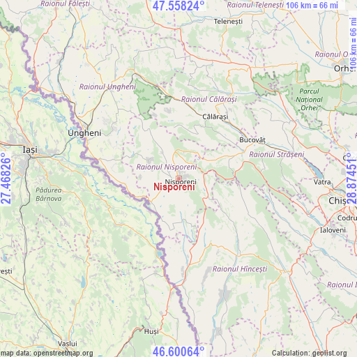
Nisporeni GPS coordinates[2]
47° 4' 53.724" North, 28° 10' 16.968" East
| Map corner | latitude | longitude |
|---|---|---|
| Upper-left | 47.55824°, | 27.46826° |
| Center: | 47.08159°, | 28.17138° |
| Lower-right: | 46.60064°, | 28.87451° |
| Map W x H: | 106.5×106.5 km | = 66.2×66.2mi |
| max Lat: | 48.43285° ⇑56.2% North |
| Nisporeni: | 47.08159° |
| min Lat: | ⇓43.8% South 45.48167° |
| min Long | Nisporeni | max Long |
| 27.07787° | 28.17138° | 29.9617° |
| W 20.5%⇐ | ⇒79.5% E |
Elevation
Elevation of Nisporeni is 120 m = 394 ft, and this is 27.2 m = 89 ft above average elevation for this country.
| Max E: |
241 m = 791 ft | 28.8% |
| Nisporeni | 120 m 394 ft | |
| Avg. | 92.8 m = 304 ft | |
Min E: |
11 m = 36 ft | 71.2% |
See also: Moldova elevation on elevation.city.
Geographical zone
Nisporeni is located in North temperate zone (between Tropic of Cancer and the Arctic Circle). Distance of this North polar circle is 2166.2 km =1346 mi to North.| Distance of | km | miles | from Nisporeni |
|---|---|---|---|
| North Pole | 4772.1 | 2965.2 | to North |
| Arctic Circle | 2166.2 | 1346 | to North |
| Tropic Cancer | 2629.1 | 1633.6 | to South |
| Equator | 5235 | 3252.9 | to South |


Nearby cities:
15 places around Nisporeni: (largest is in red/bold)
• Bucovăţ
24.8 km =15.4 mi,  60°
60°
• Chisinau
52.7 km =32.7 mi,  99°
99°
• Ciorescu
54.6 km =33.9 mi,  84°
84°
• Cricova
52.6 km =32.7 mi, 83°
• Călăraşi
22 km =13.7 mi,  28°
28°
• Dancu
36.1 km =22.4 mi,  175°
175°
• Hînceşti
42.3 km =26.3 mi,  131°
131°
• Ialoveni
48.8 km =30.3 mi,  108°
108°
• Mîndreşti
47.8 km =29.7 mi,  9°
9°
• Orhei
59.7 km =37.1 mi, 55°
• Strășeni
33.7 km =20.9 mi, 78°
• Stăuceni
52.8 km =32.8 mi,  88°
88°
• Teleneşti
48.9 km =30.4 mi,  17°
17°
• Ungheni
31.5 km =19.6 mi,  297°
297°
• Vatra
42.8 km =26.6 mi, 91°
Sources, notices
• [Note1] Compared only with cities in Moldova existing in our database
• [Src1] Map data: © OpenStreetMap contributors (CC-BY-SA)
• [Src2] Other city data from geonames.org with taken over terms of usage.
• [Src3] Geographical zone / Annual Mean Temperature by Robert A. Rohde @ Wikipedia
