Orhei geodata
Orhei is a seat of a first-order administrative division; located in Moldova in Europe/Chisinau (GMT+3) time zone. With population of 24,918 people, there are 8 cities with bigger population in this country. Compared to other cities in Moldova, 64.4% of cities are located further ↓South; 58.9% of cities are located further ←West and 53.4% of cities have higher elevation than Orhei. Note1


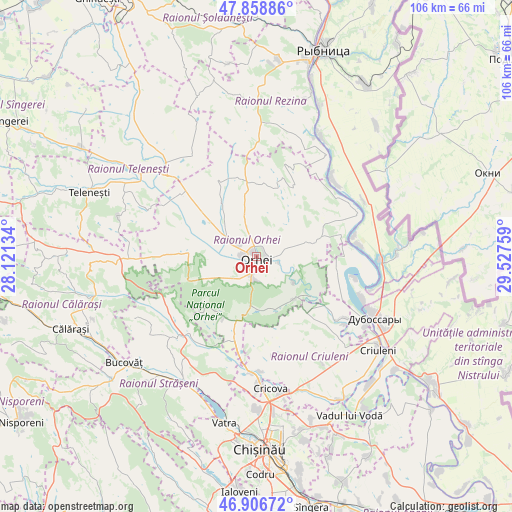
Orhei GPS coordinates[2]
47° 23' 5.784" North, 28° 49' 28.056" East
| Map corner | latitude | longitude |
|---|---|---|
| Upper-left | 47.85886°, | 28.12134° |
| Center: | 47.38494°, | 28.82446° |
| Lower-right: | 46.90672°, | 29.52759° |
| Map W x H: | 105.9×105.9 km | = 65.8×65.8mi |
| max Lat: | 48.43285° ⇑35.6% North |
| Orhei: | 47.38494° |
| min Lat: | ⇓64.4% South 45.48167° |
| min Long | Orhei | max Long |
| 27.07787° | 28.82446° | 29.9617° |
| W 58.9%⇐ | ⇒41.1% E |
Elevation
Elevation of Orhei is 86 m = 282 ft, and this is 6.8 m = 22 ft below average elevation for this country.
| Max E: |
241 m = 791 ft | 53.4% |
| Avg. | 92.8 m = 304 ft | |
| Orhei | 86 m = 282 ft | |
Min E: |
11 m = 36 ft | 46.6% |
See also: Moldova elevation on elevation.city.
Geographical zone
Orhei is located in North temperate zone (between Tropic of Cancer and the Arctic Circle). Distance of this North polar circle is 2132.5 km =1325.1 mi to North.| Distance of | km | miles | from Orhei |
|---|---|---|---|
| North Pole | 4738.4 | 2944.3 | to North |
| Arctic Circle | 2132.5 | 1325.1 | to North |
| Tropic Cancer | 2662.8 | 1654.6 | to South |
| Equator | 5268.7 | 3273.8 | to South |


Nearby cities:
15 places around Orhei: (largest is in red/bold)
• Bucovăţ
35.1 km =21.8 mi,  231°
231°
• Ciorescu
28.8 km =17.9 mi,  170°
170°
• Cocieri
23.9 km =14.9 mi,  112°
112°
• Cricova
27.6 km =17.1 mi, 174°
• Criuleni
31.7 km =19.7 mi,  127°
127°
• Călăraşi
41.4 km =25.7 mi,  249°
249°
• Dubăsari
29 km =18 mi,  117°
117°
• Rezina
41.9 km =26 mi,  14°
14°
• Saharna
35.9 km =22.3 mi,  18°
18°
• Strășeni
31.6 km =19.6 mi,  211°
211°
• Stăuceni
32.2 km =20 mi, 174°
• Teleneşti
36.9 km =22.9 mi,  290°
290°
• Ustia
26.8 km =16.7 mi, 122°
• Vadul lui Vodă
37.9 km =23.5 mi,  149°
149°
• Vatra
35.1 km =21.8 mi,  190°
190°
Sources, notices
• [Note1] Compared only with cities in Moldova existing in our database
• [Src1] Map data: © OpenStreetMap contributors (CC-BY-SA)
• [Src2] Other city data from geonames.org with taken over terms of usage.
• [Src3] Geographical zone / Annual Mean Temperature by Robert A. Rohde @ Wikipedia
