Risan geodata
Risan (Kotor) is a populated place; located in Montenegro in Europe/Podgorica (GMT+2) time zone. With population of 2,083 people, there are 22 cities with bigger population in this country. Compared to other cities in Montenegro, 60.3% of cities are located further ↓South; 88.9% of cities are located further →East and 76.2% of cities have higher elevation than Risan. Note1


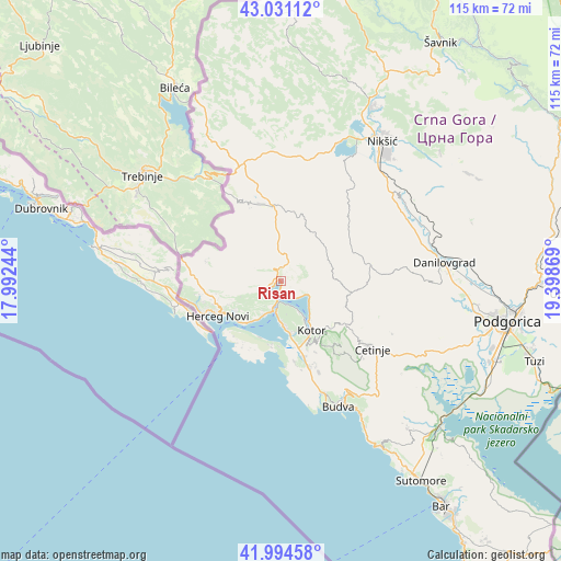
Risan GPS coordinates[2]
42° 30' 54" North, 18° 41' 44.016" East
| Map corner | latitude | longitude |
|---|---|---|
| Upper-left | 43.03112°, | 17.99244° |
| Center: | 42.515°, | 18.69556° |
| Lower-right: | 41.99458°, | 19.39869° |
| Map W x H: | 115.3×115.3 km | = 71.6×71.6mi |
| max Lat: | 43.38472° ⇑39.7% North |
| Risan: | 42.515° |
| min Lat: | ⇓60.3% South 41.92936° |
| min Long | Risan | max Long |
| 18.50647° | 18.69556° | 20.16652° |
| W 11.1%⇐ | ⇒88.9% E |
Elevation
Elevation of Risan is 12 m = 39 ft, and this is 334 m = 1096 ft below average elevation for this country.
| Max E: |
1448 m = 4751 ft | 76.2% |
| Avg. | 346 m = 1135 ft | |
| Risan | 12 m = 39 ft | |
Min E: |
4 m = 13 ft | 23.8% |
See also: Montenegro elevation on elevation.city.
Geographical zone
Risan is located in North temperate zone (between Tropic of Cancer and the Arctic Circle). Distance of this Northern Tropic circle is 2121.3 km =1318.1 mi to South.| Distance of | km | miles | from Risan |
|---|---|---|---|
| North Pole | 5279.8 | 3280.7 | to North |
| Arctic Circle | 2673.9 | 1661.5 | to North |
| Tropic Cancer | 2121.3 | 1318.1 | to South |
| Equator | 4727.2 | 2937.3 | to South |


Nearby cities:
15 places around Risan: (largest is in red/bold)
• Baošići
9.7 km =6 mi,  213°
213°
• Bijela
7.6 km =4.7 mi, 205°
• Dobrota
9 km =5.6 mi,  138°
138°
• Donja Lastva
8 km =5 mi,  184°
184°
• Herceg-Novi
14.7 km =9.1 mi,  242°
242°
• Kotor
12.1 km =7.5 mi,  150°
150°
• Lipci
3.7 km =2.3 mi, 237°
• Mrčevac
10.7 km =6.6 mi,  170°
170°
• Muo
10.6 km =6.6 mi, 151°
• Njeguši
13 km =8.1 mi,  133°
133°
• Perast
3.1 km =1.9 mi, 174°
• Prčanj
7.5 km =4.7 mi, 149°
• Tivat
8.7 km =5.4 mi, 179°
• Ðenovići
11.6 km =7.2 mi,  221°
221°
• Škaljari
12.2 km =7.6 mi, 151°
Sources, notices
• [Note1] Compared only with cities in Montenegro existing in our database
• [Src1] Map data: © OpenStreetMap contributors (CC-BY-SA)
• [Src2] Other city data from geonames.org with taken over terms of usage.
• [Src3] Geographical zone / Annual Mean Temperature by Robert A. Rohde @ Wikipedia
