Perast geodata
Perast (Kotor) is a populated place; located in Montenegro in Europe/Podgorica (GMT+2) time zone. With population of 551 people, there are 52 cities with bigger population in this country. Compared to other cities in Montenegro, 55.6% of cities are located further ↓South; 85.7% of cities are located further →East and 61.9% of cities have higher elevation than Perast. Note1


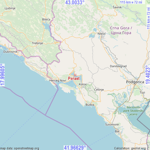
Perast GPS coordinates[2]
42° 29' 12.984" North, 18° 41' 57.012" East
| Map corner | latitude | longitude |
|---|---|---|
| Upper-left | 43.0033°, | 17.99605° |
| Center: | 42.48694°, | 18.69917° |
| Lower-right: | 41.96629°, | 19.4023° |
| Map W x H: | 115.3×115.3 km | = 71.6×71.6mi |
| max Lat: | 43.38472° ⇑44.4% North |
| Perast: | 42.48694° |
| min Lat: | ⇓55.6% South 41.92936° |
| min Long | Perast | max Long |
| 18.50647° | 18.69917° | 20.16652° |
| W 14.3%⇐ | ⇒85.7% E |
Elevation
Elevation of Perast is 29 m = 95 ft, and this is 317 m = 1040 ft below average elevation for this country.
| Max E: |
1448 m = 4751 ft | 61.9% |
| Avg. | 346 m = 1135 ft | |
| Perast | 29 m = 95 ft | |
Min E: |
4 m = 13 ft | 38.1% |
See also: Montenegro elevation on elevation.city.
Geographical zone
Perast is located in North temperate zone (between Tropic of Cancer and the Arctic Circle). Distance of this Northern Tropic circle is 2118.2 km =1316.2 mi to South.| Distance of | km | miles | from Perast |
|---|---|---|---|
| North Pole | 5283 | 3282.7 | to North |
| Arctic Circle | 2677.1 | 1663.5 | to North |
| Tropic Cancer | 2118.2 | 1316.2 | to South |
| Equator | 4724.1 | 2935.4 | to South |


Nearby cities:
15 places around Perast: (largest is in red/bold)
• Baošići
7.5 km =4.7 mi,  228°
228°
• Bijela
5.2 km =3.2 mi,  223°
223°
• Dobrota
6.7 km =4.2 mi,  122°
122°
• Donja Lastva
5 km =3.1 mi,  190°
190°
• Herceg-Novi
13.8 km =8.6 mi,  254°
254°
• Kotor
9.3 km =5.8 mi,  142°
142°
• Lipci
3.6 km =2.2 mi,  288°
288°
• Mrčevac
7.6 km =4.7 mi,  168°
168°
• Muo
7.8 km =4.8 mi, 142°
• Njeguši
10.9 km =6.8 mi, 122°
• Prčanj
4.8 km =3 mi,  132°
132°
• Risan
3.1 km =1.9 mi,  354°
354°
• Tivat
5.6 km =3.5 mi,  182°
182°
• Ðenovići
9.7 km =6 mi,  235°
235°
• Škaljari
9.4 km =5.8 mi, 144°
Sources, notices
• [Note1] Compared only with cities in Montenegro existing in our database
• [Src1] Map data: © OpenStreetMap contributors (CC-BY-SA)
• [Src2] Other city data from geonames.org with taken over terms of usage.
• [Src3] Geographical zone / Annual Mean Temperature by Robert A. Rohde @ Wikipedia
