Betafo geodata
Betafo (Vakinankaratra) is a populated place; located in Madagascar in Indian/Antananarivo (GMT+3) time zone. With population of 29,785 people, there are 34 cities with bigger population in this country. Compared to other cities in Madagascar, 59.3% of cities are located further ↑North; 69.9% of cities are located further →East and 82.9% of cities have lower elevation than Betafo. Note1
Administrative division(s):
- Level 1: Vakinankaratra
- Level 2: Betafo District
- Level 3: Betafo
- Level 4: Ambohipihaonana


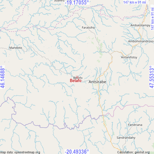
Betafo GPS coordinates[2]
19° 49' 59.988" South, 46° 51' 0" East
| Map corner | latitude | longitude |
|---|---|---|
| Upper-left | -19.17055°, | 46.14688° |
| Center: | -19.83333°, | 46.85° |
| Lower-right: | -20.49336°, | 47.55313° |
| Map W x H: | 147.1×147.1 km | = 91.4×91.4mi |
| max Lat: | -12.31732° ⇑59.3% North |
| Betafo: | -19.83333° |
| min Lat: | ⇓40.7% South -25.3° |
| min Long | Betafo | max Long |
| 43.65° | 46.85° | 50.27876° |
| W 30.1%⇐ | ⇒69.9% E |
Elevation
Elevation of Betafo is 1371 m = 4498 ft, and this is 813.6 m = 2669 ft above average elevation for this country.
| Max E: |
1763 m = 5784 ft | 17.1% |
| Betafo | 1371 m 4498 ft | |
| Avg. | 557.4 m = 1829 ft | |
Min E: |
1 m = 3 ft | 82.9% |
See also: Madagascar elevation on elevation.city.
Geographical zone
Betafo is located in South Torrid zone (between Equator and Tropic of Capricorn). Distance of this Southern Tropic circle is 400.7 km =249 mi to South.| Distance of | km | miles | from Betafo |
|---|---|---|---|
| Equator | 2205.3 | 1370.3 | to North |
| Tropic Capricorn | 400.7 | 249 | to South |
| Antarctic Circle | 5195.9 | 3228.6 | to South |
| South Pole | 7801.8 | 4847.8 | to South |


Nearby cities:
15 places around Betafo: (largest is in red/bold)
• Ambatofinandrahana
80.1 km =49.8 mi,  183°
183°
• Ambatolampy
77.6 km =48.2 mi,  49°
49°
• Ambositra
87.7 km =54.5 mi,  152°
152°
• Andramasina
105.7 km =65.7 mi, 47°
• Antananarivo
125 km =77.7 mi,  35°
35°
• Antanifotsy
52.9 km =32.9 mi,  67°
67°
• Antsampanimahazo
38.6 km =24 mi,  56°
56°
• Antsirabe
19.5 km =12.1 mi,  100°
100°
• Arivonimamo
97.3 km =60.5 mi,  21°
21°
• Fandriana
71.3 km =44.3 mi,  128°
128°
• Faratsiho
49.3 km =30.6 mi,  12°
12°
• Miandrarivo
45.7 km =28.4 mi,  346°
346°
• Miarinarivo
97.4 km =60.5 mi,  3°
3°
• Soanindrariny
40.8 km =25.4 mi, 100°
• Soavinandriana
75.1 km =46.7 mi, 350°
Sources, notices
• [Note1] Compared only with cities in Madagascar existing in our database
• [Src1] Map data: © OpenStreetMap contributors (CC-BY-SA)
• [Src2] Other city data from geonames.org with taken over terms of usage.
• [Src3] Geographical zone / Annual Mean Temperature by Robert A. Rohde @ Wikipedia
