Fandriana geodata
Fandriana (Amoron'i Mania) is a populated place; located in Madagascar in Indian/Antananarivo (GMT+3) time zone. With population of 31,437 people, there are 28 cities with bigger population in this country. Compared to other cities in Madagascar, 63.4% of cities are located further ↑North; 56.9% of cities are located further →East and 81.3% of cities have lower elevation than Fandriana. Note1
Administrative division(s):
- Level 1: Amoron'i Mania
- Level 2: Fandriana District
- Level 3: Fandriana
- Level 4: Anteza


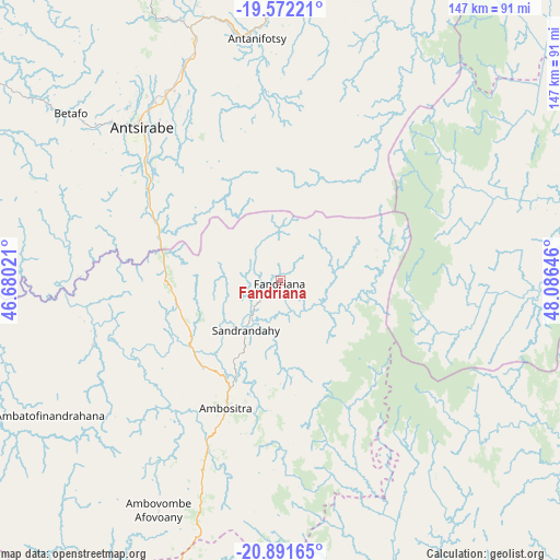
Fandriana GPS coordinates[2]
20° 13' 59.988" South, 47° 22' 59.988" East
| Map corner | latitude | longitude |
|---|---|---|
| Upper-left | -19.57221°, | 46.68021° |
| Center: | -20.23333°, | 47.38333° |
| Lower-right: | -20.89165°, | 48.08646° |
| Map W x H: | 146.7×146.7 km | = 91.2×91.2mi |
| max Lat: | -12.31732° ⇑63.4% North |
| Fandriana: | -20.23333° |
| min Lat: | ⇓36.6% South -25.3° |
| min Long | Fandriana | max Long |
| 43.65° | 47.38333° | 50.27876° |
| W 43.1%⇐ | ⇒56.9% E |
Elevation
Elevation of Fandriana is 1364 m = 4475 ft, and this is 806.6 m = 2646 ft above average elevation for this country.
| Max E: |
1763 m = 5784 ft | 18.7% |
| Fandriana | 1364 m 4475 ft | |
| Avg. | 557.4 m = 1829 ft | |
Min E: |
1 m = 3 ft | 81.3% |
See also: Madagascar elevation on elevation.city.
Geographical zone
Fandriana is located in South Torrid zone (between Equator and Tropic of Capricorn). Distance of this Southern Tropic circle is 356.2 km =221.3 mi to South.| Distance of | km | miles | from Fandriana |
|---|---|---|---|
| Equator | 2249.7 | 1397.9 | to North |
| Tropic Capricorn | 356.2 | 221.3 | to South |
| Antarctic Circle | 5151.4 | 3200.9 | to South |
| South Pole | 7757.3 | 4820.2 | to South |


Nearby cities:
15 places around Fandriana: (largest is in red/bold)
• Ambatofinandrahana
70.1 km =43.6 mi,  239°
239°
• Ambatolampy
94.6 km =58.8 mi,  2°
2°
• Ambositra
36.1 km =22.4 mi,  203°
203°
• Andramasina
118.2 km =73.4 mi,  10°
10°
• Antanifotsy
65.2 km =40.5 mi,  353°
353°
• Antsampanimahazo
70.1 km =43.6 mi,  340°
340°
• Antsirabe
54.8 km =34.1 mi,  318°
318°
• Betafo
71.3 km =44.3 mi,  308°
308°
• Faratsiho
103.2 km =64.1 mi,  333°
333°
• Ifanadiana
121.4 km =75.4 mi,  167°
167°
• Marolambo
79.2 km =49.2 mi,  75°
75°
• Miandrarivo
110.9 km =68.9 mi, 323°
• Nosy Varika
126 km =78.3 mi,  107°
107°
• Sahavato
107.1 km =66.5 mi, 112°
• Soanindrariny
40.2 km =25 mi, 337°
Sources, notices
• [Note1] Compared only with cities in Madagascar existing in our database
• [Src1] Map data: © OpenStreetMap contributors (CC-BY-SA)
• [Src2] Other city data from geonames.org with taken over terms of usage.
• [Src3] Geographical zone / Annual Mean Temperature by Robert A. Rohde @ Wikipedia
