Soavinandriana geodata
Soavinandriana (Itasy) is a populated place; located in Madagascar in Indian/Antananarivo (GMT+3) time zone. With population of 40,453 people, there are 14 cities with bigger population in this country. Compared to other cities in Madagascar, 52% of cities are located further ↑North; 73.2% of cities are located further →East and 92.7% of cities have lower elevation than Soavinandriana. Note1
Administrative division(s):
- Level 1: Itasy
- Level 2: Soavinandriana
- Level 3: Soavinandriana
- Level 4: Ampitsaharana


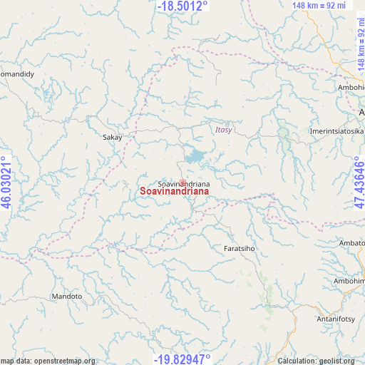
Soavinandriana GPS coordinates[2]
19° 10' 0.012" South, 46° 43' 59.988" East
| Map corner | latitude | longitude |
|---|---|---|
| Upper-left | -18.5012°, | 46.03021° |
| Center: | -19.16667°, | 46.73333° |
| Lower-right: | -19.82947°, | 47.43646° |
| Map W x H: | 147.7×147.7 km | = 91.8×91.8mi |
| max Lat: | -12.31732° ⇑52% North |
| Soavinandriana: | -19.16667° |
| min Lat: | ⇓48% South -25.3° |
| min Long | Soavinandriana | max Long |
| 43.65° | 46.73333° | 50.27876° |
| W 26.8%⇐ | ⇒73.2% E |
Elevation
Elevation of Soavinandriana is 1500 m = 4921 ft, and this is 942.6 m = 3093 ft above average elevation for this country.
| Max E: |
1763 m = 5784 ft | 7.3% |
| Soavinandriana | 1500 m 4921 ft | |
| Avg. | 557.4 m = 1829 ft | |
Min E: |
1 m = 3 ft | 92.7% |
See also: Soavinandriana elevation on elevation.city.
Geographical zone
Soavinandriana is located in South Torrid zone (between Equator and Tropic of Capricorn). Distance of this Southern Tropic circle is 474.8 km =295 mi to South.| Distance of | km | miles | from Soavinandriana |
|---|---|---|---|
| Equator | 2131.1 | 1324.2 | to North |
| Tropic Capricorn | 474.8 | 295 | to South |
| Antarctic Circle | 5270 | 3274.6 | to South |
| South Pole | 7875.9 | 4893.9 | to South |


Nearby cities:
15 places around Soavinandriana: (largest is in red/bold)
• Ambatolampy
75.7 km =47 mi,  108°
108°
• Andramasina
90 km =55.9 mi,  91°
91°
• Ankazobe
102.8 km =63.9 mi,  23°
23°
• Antananarivo
88.9 km =55.2 mi,  71°
71°
• Antanifotsy
81.4 km =50.6 mi,  131°
131°
• Antsampanimahazo
68.8 km =42.8 mi,  139°
139°
• Antsirabe
83.9 km =52.1 mi,  157°
157°
• Arivonimamo
50.1 km =31.1 mi, 70°
• Betafo
75.1 km =46.7 mi,  170°
170°
• Faratsiho
34.5 km =21.4 mi, 138°
• Fenoarivo Be
83.4 km =51.8 mi,  347°
347°
• Miandrarivo
29.7 km =18.5 mi,  176°
176°
• Miarinarivo
29.4 km =18.3 mi,  38°
38°
• Soanindrariny
96.9 km =60.2 mi,  147°
147°
• Tsiroanomandidy
84.6 km =52.6 mi,  301°
301°
Sources, notices
• [Note1] Compared only with cities in Madagascar existing in our database
• [Src1] Map data: © OpenStreetMap contributors (CC-BY-SA)
• [Src2] Other city data from geonames.org with taken over terms of usage.
• [Src3] Geographical zone / Annual Mean Temperature by Robert A. Rohde @ Wikipedia
