Mandalgovi geodata
Mandalgovi (Middle Govĭ) is a seat of a first-order administrative division; located in Mongolia in Asia/Ulaanbaatar (GMT+8) time zone. With population of 15,430 people, there are 19 cities with bigger population in this country. Compared to other cities in Mongolia, 83.4% of cities are located further ↑North; 73% of cities are located further ←West and 53.7% of cities have lower elevation than Mandalgovi. Note1


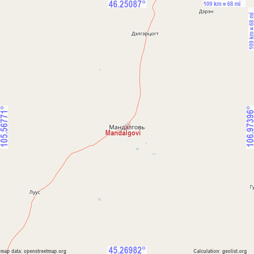
Mandalgovi GPS coordinates[2]
45° 45' 45" North, 106° 16' 14.988" East
| Map corner | latitude | longitude |
|---|---|---|
| Upper-left | 46.25087°, | 105.56771° |
| Center: | 45.7625°, | 106.27083° |
| Lower-right: | 45.26982°, | 106.97396° |
| Map W x H: | 109.1×109.1 km | = 67.8×67.8mi |
| max Lat: | 51.50725° ⇑83.4% North |
| Mandalgovi: | 45.7625° |
| min Lat: | ⇓16.6% South 42.84199° |
| min Long | Mandalgovi | max Long |
| 89.14358° | 106.27083° | 118.51014° |
| W 73%⇐ | ⇒27% E |
Elevation
Elevation of Mandalgovi is 1424 m = 4672 ft, and this is 7.5 m = 25 ft above average elevation for this country.
| Max E: |
2800 m = 9186 ft | 46.3% |
| Mandalgovi | 1424 m 4672 ft | |
| Avg. | 1416.5 m = 4647 ft | |
Min E: |
619 m = 2031 ft | 53.7% |
See also: Mongolia elevation on elevation.city.
Geographical zone
Mandalgovi is located in North temperate zone (between Tropic of Cancer and the Arctic Circle). Distance of this North polar circle is 2312.9 km =1437.2 mi to North.| Distance of | km | miles | from Mandalgovi |
|---|---|---|---|
| North Pole | 4918.7 | 3056.3 | to North |
| Arctic Circle | 2312.9 | 1437.2 | to North |
| Tropic Cancer | 2482.4 | 1542.5 | to South |
| Equator | 5088.3 | 3161.7 | to South |


Nearby cities:
15 places around Mandalgovi: (largest is in red/bold)
• Amardalay
41.2 km =25.6 mi,  11°
11°
• Argatay
132.8 km =82.5 mi,  89°
89°
• Bayanbaraat
122.8 km =76.3 mi,  359°
359°
• Bayantöhöm
158.9 km =98.7 mi,  323°
323°
• Dzogsool
133.7 km =83.1 mi,  30°
30°
• Hajuu-Us
99.6 km =61.9 mi,  71°
71°
• Haraat
128.8 km =80 mi,  55°
55°
• Hashaat
128 km =79.5 mi,  243°
243°
• Rashaant
51.7 km =32.1 mi,  186°
186°
• Sangiyn Dalay
106.4 km =66.1 mi,  284°
284°
• Suugaant
65.4 km =40.6 mi,  113°
113°
• Tavin
81.3 km =50.5 mi,  329°
329°
• Tsagaan-Ovoo
49.1 km =30.5 mi,  234°
234°
• Tsant
58.1 km =36.1 mi,  36°
36°
• Ulaanjirem
96.4 km =59.9 mi,  214°
214°
Sources, notices
• [Note1] Compared only with cities in Mongolia existing in our database
• [Src1] Map data: © OpenStreetMap contributors (CC-BY-SA)
• [Src2] Other city data from geonames.org with taken over terms of usage.
• [Src3] Geographical zone / Annual Mean Temperature by Robert A. Rohde @ Wikipedia
