Hashaat geodata
Hashaat (Middle Govĭ) is a seat of a second-order administrative division; located in Mongolia in Asia/Ulaanbaatar (GMT+8) time zone. In our database, there are 33 cities with bigger population. Compared to other cities in Mongolia, 89% of cities are located further ↑North; 62.3% of cities are located further ←West and 58.3% of cities have lower elevation than Hashaat. Note1


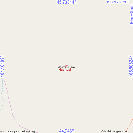
Hashaat GPS coordinates[2]
45° 14' 35.628" North, 104° 48' 18.396" East
| Map corner | latitude | longitude |
|---|---|---|
| Upper-left | 45.73614°, | 104.10199° |
| Center: | 45.24323°, | 104.80511° |
| Lower-right: | 44.746°, | 105.50824° |
| Map W x H: | 110.1×110.1 km | = 68.4×68.4mi |
| max Lat: | 51.50725° ⇑89% North |
| Hashaat: | 45.24323° |
| min Lat: | ⇓11% South 42.84199° |
| min Long | Hashaat | max Long |
| 89.14358° | 104.80511° | 118.51014° |
| W 62.3%⇐ | ⇒37.7% E |
Elevation
Elevation of Hashaat is 1463 m = 4800 ft, and this is 46.5 m = 153 ft above average elevation for this country.
| Max E: |
2800 m = 9186 ft | 41.7% |
| Hashaat | 1463 m 4800 ft | |
| Avg. | 1416.5 m = 4647 ft | |
Min E: |
619 m = 2031 ft | 58.3% |
See also: Mongolia elevation on elevation.city.
Geographical zone
Hashaat is located in North temperate zone (between Tropic of Cancer and the Arctic Circle). Distance of this North polar circle is 2370.6 km =1473 mi to North.| Distance of | km | miles | from Hashaat |
|---|---|---|---|
| North Pole | 4976.5 | 3092.3 | to North |
| Arctic Circle | 2370.6 | 1473 | to North |
| Tropic Cancer | 2424.7 | 1506.6 | to South |
| Equator | 5030.6 | 3125.9 | to South |


Nearby cities:
15 places around Hashaat: (largest is in red/bold)
• Amardalay
156.5 km =97.2 mi,  51°
51°
• Bumbat
149.2 km =92.7 mi,  339°
339°
• Doloon
99.7 km =62 mi,  155°
155°
• Hoolt
145.9 km =90.7 mi,  282°
282°
• Hujirt
151.8 km =94.3 mi,  353°
353°
• Mandalgovi
128 km =79.5 mi,  63°
63°
• Mayhan
120.5 km =74.9 mi,  321°
321°
• Ongi
74.4 km =46.2 mi,  288°
288°
• Rashaant
109.3 km =67.9 mi,  86°
86°
• Sangiyn Dalay
85.7 km =53.3 mi,  7°
7°
• Sharhulsan
88.8 km =55.2 mi,  222°
222°
• Shiree
128.5 km =79.8 mi,  301°
301°
• Tavin
146.7 km =91.2 mi,  29°
29°
• Tsagaan-Ovoo
79.9 km =49.6 mi,  68°
68°
• Ulaanjirem
63.5 km =39.5 mi,  109°
109°
Sources, notices
• [Note1] Compared only with cities in Mongolia existing in our database
• [Src1] Map data: © OpenStreetMap contributors (CC-BY-SA)
• [Src2] Other city data from geonames.org with taken over terms of usage.
• [Src3] Geographical zone / Annual Mean Temperature by Robert A. Rohde @ Wikipedia
