Le Lorrain geodata
Le Lorrain (Martinique) is a populated place; located in Martinique in America/Martinique (GMT-4) time zone. With population of 8,341 people, there are 12 cities with bigger population in this country. Compared to other cities in Martinique, 94.7% of cities are located further ↓South; 73.7% of cities are located further →East and 73.7% of cities have higher elevation than Le Lorrain. Note1
Administrative division(s):
- Level 1: Martinique
- Level 2: Martinique
- Level 3: Arrondissement de La Trinité
- Level 4: Le Lorrain


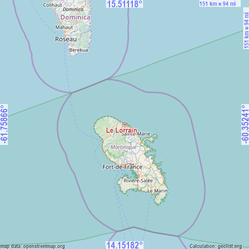
Le Lorrain GPS coordinates[2]
14° 49' 57.252" North, 61° 3' 19.908" West
| Map corner | latitude | longitude |
|---|---|---|
| Upper-left | 15.51118°, | -61.75866° |
| Center: | 14.83257°, | -61.05553° |
| Lower-right: | 14.15182°, | -60.35241° |
| Map W x H: | 151.1×151.1 km | = 93.9×93.9mi |
| max Lat: | 14.86935° ⇑5.3% North |
| Le Lorrain: | 14.83257° |
| min Lat: | ⇓94.7% South 14.46848° |
| min Long | Le Lorrain | max Long |
| -61.17541° | -61.05553° | -60.83831° |
| W 26.3%⇐ | ⇒73.7% E |
Elevation
Elevation of Le Lorrain is 13 m = 43 ft, and this is 47.8 m = 157 ft below average elevation for this country.
| Max E: |
459 m = 1506 ft | 73.7% |
| Avg. | 60.8 m = 199 ft | |
| Le Lorrain | 13 m = 43 ft | |
Min E: |
6 m = 20 ft | 26.3% |
See also: Martinique elevation on elevation.city.
Geographical zone
Le Lorrain is located in North Torrid zone (between Equator and Tropic of Cancer). Distance of this Northern Tropic circle is 956.7 km =594.5 mi to North.| Distance of | km | miles | from Le Lorrain |
|---|---|---|---|
| North Pole | 8357.8 | 5193.3 | to North |
| Arctic Circle | 5751.9 | 3574.1 | to North |
| Tropic Cancer | 956.7 | 594.5 | to North |
| Equator | 1649.2 | 1024.8 | to South |


Nearby cities:
15 places around Le Lorrain: (largest is in red/bold)
• Basse-Pointe
7.6 km =4.7 mi,  302°
302°
• Ducos
29.9 km =18.6 mi,  163°
163°
• Fort-de-France
25.5 km =15.8 mi,  184°
184°
• La Trinité
14.5 km =9 mi,  136°
136°
• Le François
29.2 km =18.1 mi,  145°
145°
• Le Gros-Morne
15.9 km =9.9 mi, 157°
• Le Lamentin
25.1 km =15.6 mi,  166°
166°
• Le Morne-Rouge
10.7 km =6.6 mi,  233°
233°
• Le Robert
21.1 km =13.1 mi, 144°
• Les Trois-Îlets
32.7 km =20.3 mi, 175°
• Saint-Esprit
34.1 km =21.2 mi, 157°
• Saint-Joseph
18.1 km =11.2 mi, 174°
• Saint-Pierre
16.3 km =10.1 mi, 232°
• Sainte-Marie
8.7 km =5.4 mi,  128°
128°
• Schoelcher
24.3 km =15.1 mi,  191°
191°
Sources, notices
• [Note1] Compared only with cities in Martinique existing in our database
• [Src1] Map data: © OpenStreetMap contributors (CC-BY-SA)
• [Src2] Other city data from geonames.org with taken over terms of usage.
• [Src3] Geographical zone / Annual Mean Temperature by Robert A. Rohde @ Wikipedia
