Imtarfa geodata
Imtarfa (L-Imtarfa) is a seat of a first-order administrative division; located in Malta in Europe/Malta (GMT+2) time zone. With population of 2,430 people, there are 54 cities with bigger population in this country. Compared to other cities in Malta, 53.5% of cities are located further ↑North; 70.4% of cities are located further →East and 95.8% of cities have lower elevation than Imtarfa. Note1


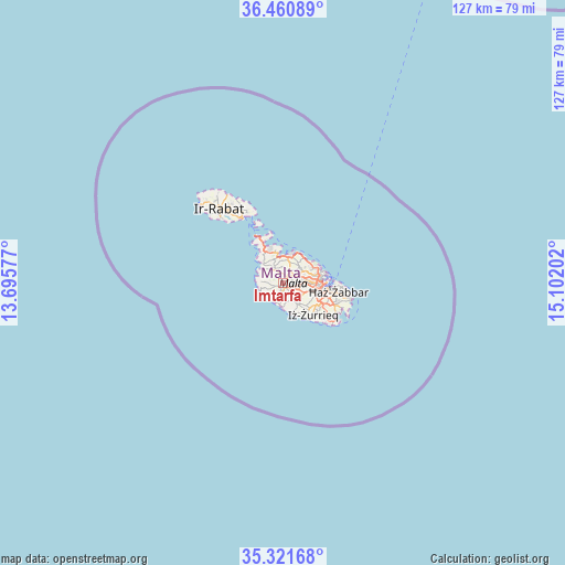
Imtarfa GPS coordinates[2]
35° 53' 35.988" North, 14° 23' 56.004" East
| Map corner | latitude | longitude |
|---|---|---|
| Upper-left | 36.46089°, | 13.69577° |
| Center: | 35.89333°, | 14.39889° |
| Lower-right: | 35.32168°, | 15.10202° |
| Map W x H: | 126.7×126.7 km | = 78.7×78.7mi |
| max Lat: | 36.07222° ⇑53.5% North |
| Imtarfa: | 35.89333° |
| min Lat: | ⇓46.5% South 35.82583° |
| min Long | Imtarfa | max Long |
| 14.20361° | 14.39889° | 14.56701° |
| W 29.6%⇐ | ⇒70.4% E |
Elevation
Elevation of Imtarfa is 195 m = 640 ft, and this is 116.9 m = 384 ft above average elevation for this country.
| Max E: |
231 m = 758 ft | 4.2% |
| Imtarfa | 195 m 640 ft | |
| Avg. | 78.1 m = 256 ft | |
Min E: |
5 m = 16 ft | 95.8% |
See also: Malta elevation on elevation.city.
Geographical zone
Imtarfa is located in North temperate zone (between Tropic of Cancer and the Arctic Circle). Distance of this Northern Tropic circle is 1385 km =860.6 mi to South.| Distance of | km | miles | from Imtarfa |
|---|---|---|---|
| North Pole | 6016.1 | 3738.2 | to North |
| Arctic Circle | 3410.2 | 2119 | to North |
| Tropic Cancer | 1385 | 860.6 | to South |
| Equator | 3991 | 2479.9 | to South |


Nearby cities:
15 places around Imtarfa: (largest is in red/bold)
• Attard
3.9 km =2.4 mi,  95°
95°
• Balzan
5.1 km =3.2 mi,  81°
81°
• Birkirkara
5.6 km =3.5 mi,  85°
85°
• Dingli
3.9 km =2.4 mi,  202°
202°
• Hal Gharghur
5.8 km =3.6 mi,  54°
54°
• Haz-Zebbug
4.5 km =2.8 mi,  122°
122°
• Imdina
0.8 km =0.5 mi,  155°
155°
• Imġarr
4.2 km =2.6 mi,  315°
315°
• L-Iklin
5.1 km =3.2 mi, 76°
• Lija
4.4 km =2.7 mi, 79°
• Mosta
3 km =1.9 mi, 53°
• Naxxar
4.6 km =2.9 mi,  60°
60°
• Rabat
1.3 km =0.8 mi,  180°
180°
• San Pawl il-Baħar
6.5 km =4 mi,  13°
13°
• Siġġiewi
5.4 km =3.4 mi,  141°
141°
Sources, notices
• [Note1] Compared only with cities in Malta existing in our database
• [Src1] Map data: © OpenStreetMap contributors (CC-BY-SA)
• [Src2] Other city data from geonames.org with taken over terms of usage.
• [Src3] Geographical zone / Annual Mean Temperature by Robert A. Rohde @ Wikipedia
