Naxxar geodata
Naxxar (In-Naxxar) is a seat of a first-order administrative division; located in Malta in Europe/Malta (GMT+2) time zone. With population of 10,378 people, there are 11 cities with bigger population in this country. Compared to other cities in Malta, 64.8% of cities are located further ↓South; 60.6% of cities are located further →East and 81.7% of cities have lower elevation than Naxxar. Note1


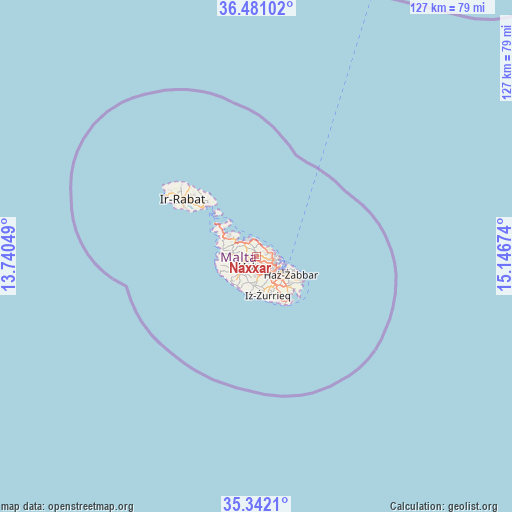
Naxxar GPS coordinates[2]
35° 54' 48.996" North, 14° 26' 36.996" East
| Map corner | latitude | longitude |
|---|---|---|
| Upper-left | 36.48102°, | 13.74049° |
| Center: | 35.91361°, | 14.44361° |
| Lower-right: | 35.3421°, | 15.14674° |
| Map W x H: | 126.6×126.6 km | = 78.7×78.7mi |
| max Lat: | 36.07222° ⇑35.2% North |
| Naxxar: | 35.91361° |
| min Lat: | ⇓64.8% South 35.82583° |
| min Long | Naxxar | max Long |
| 14.20361° | 14.44361° | 14.56701° |
| W 39.4%⇐ | ⇒60.6% E |
Elevation
Elevation of Naxxar is 121 m = 397 ft, and this is 42.9 m = 141 ft above average elevation for this country.
| Max E: |
231 m = 758 ft | 18.3% |
| Naxxar | 121 m 397 ft | |
| Avg. | 78.1 m = 256 ft | |
Min E: |
5 m = 16 ft | 81.7% |
See also: Malta elevation on elevation.city.
Geographical zone
Naxxar is located in North temperate zone (between Tropic of Cancer and the Arctic Circle). Distance of this Northern Tropic circle is 1387.3 km =862 mi to South.| Distance of | km | miles | from Naxxar |
|---|---|---|---|
| North Pole | 6013.8 | 3736.8 | to North |
| Arctic Circle | 3408 | 2117.6 | to North |
| Tropic Cancer | 1387.3 | 862 | to South |
| Equator | 3993.2 | 2481.3 | to South |


Nearby cities:
15 places around Naxxar: (largest is in red/bold)
• Attard
2.7 km =1.7 mi,  182°
182°
• Balzan
1.8 km =1.1 mi,  145°
145°
• Birkirkara
2.4 km =1.5 mi,  139°
139°
• Gżira
4.1 km =2.5 mi,  102°
102°
• Hal Gharghur
1.3 km =0.8 mi,  30°
30°
• Imsida
4.2 km =2.6 mi,  123°
123°
• L-Iklin
1.4 km =0.9 mi, 137°
• Lija
1.5 km =0.9 mi,  170°
170°
• Mosta
1.7 km =1.1 mi,  253°
253°
• Pembroke
3.5 km =2.2 mi,  57°
57°
• Saint John
3.1 km =1.9 mi,  107°
107°
• San Ġiljan
4.2 km =2.6 mi,  82°
82°
• Santa Venera
3.7 km =2.3 mi,  132°
132°
• Sprachcaffe
3.4 km =2.1 mi,  67°
67°
• Swieqi
3.4 km =2.1 mi, 73°
Sources, notices
• [Note1] Compared only with cities in Malta existing in our database
• [Src1] Map data: © OpenStreetMap contributors (CC-BY-SA)
• [Src2] Other city data from geonames.org with taken over terms of usage.
• [Src3] Geographical zone / Annual Mean Temperature by Robert A. Rohde @ Wikipedia
