Rose Belle geodata
Rose Belle (Grand Port) is a seat of a first-order administrative division; located in Mauritius in Indian/Mauritius (GMT+4) time zone. With population of 12,619 people, there are 13 cities with bigger population in this country. Compared to other cities in Mauritius, 86.9% of cities are located further ↑North; 51.5% of cities are located further →East and 78.8% of cities have lower elevation than Rose Belle. Note1


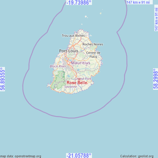
Rose Belle GPS coordinates[2]
20° 24' 1.008" South, 57° 35' 48.012" East
| Map corner | latitude | longitude |
|---|---|---|
| Upper-left | -19.73986°, | 56.89355° |
| Center: | -20.40028°, | 57.59667° |
| Lower-right: | -21.05788°, | 58.2998° |
| Map W x H: | 146.6×146.6 km | = 91.1×91.1mi |
| max Lat: | -10.38803° ⇑86.9% North |
| Rose Belle: | -20.40028° |
| min Lat: | ⇓13.1% South -20.51667° |
| min Long | Rose Belle | max Long |
| 56.61795° | 57.59667° | 63.41667° |
| W 48.5%⇐ | ⇒51.5% E |
Elevation
Elevation of Rose Belle is 286 m = 938 ft, and this is 133.9 m = 439 ft above average elevation for this country.
| Max E: |
467 m = 1532 ft | 21.2% |
| Rose Belle | 286 m 938 ft | |
| Avg. | 152.1 m = 499 ft | |
Min E: |
1 m = 3 ft | 78.8% |
See also: Mauritius elevation on elevation.city.
Geographical zone
Rose Belle is located in South Torrid zone (between Equator and Tropic of Capricorn). Distance of this Southern Tropic circle is 337.6 km =209.8 mi to South.| Distance of | km | miles | from Rose Belle |
|---|---|---|---|
| Equator | 2268.3 | 1409.5 | to North |
| Tropic Capricorn | 337.6 | 209.8 | to South |
| Antarctic Circle | 5132.9 | 3189.4 | to South |
| South Pole | 7738.8 | 4808.7 | to South |


Nearby cities:
15 places around Rose Belle: (largest is in red/bold)
• Bananes
6 km =3.7 mi,  351°
351°
• Beau Vallon
10.5 km =6.5 mi,  101°
101°
• Camp Diable
7.2 km =4.5 mi,  194°
194°
• Cluny
3.8 km =2.4 mi,  11°
11°
• Curepipe
11.9 km =7.4 mi,  321°
321°
• Dubreuil
11 km =6.8 mi,  1°
1°
• Grand Bois
5.8 km =3.6 mi,  249°
249°
• Mahébourg
10.8 km =6.7 mi,  94°
94°
• Midlands
9.4 km =5.8 mi,  342°
342°
• New Grove
2 km =1.2 mi,  117°
117°
• Nouvelle France
5 km =3.1 mi,  311°
311°
• Plaine Magnien
8.3 km =5.2 mi,  113°
113°
• Rivière des Anguilles
10.6 km =6.6 mi,  206°
206°
• Saint Aubin
11.7 km =7.3 mi,  204°
204°
• Saint Hubert
5.9 km =3.7 mi,  47°
47°
Sources, notices
• [Note1] Compared only with cities in Mauritius existing in our database
• [Src1] Map data: © OpenStreetMap contributors (CC-BY-SA)
• [Src2] Other city data from geonames.org with taken over terms of usage.
• [Src3] Geographical zone / Annual Mean Temperature by Robert A. Rohde @ Wikipedia
