Cluny geodata
Cluny (Grand Port) is a populated place; located in Mauritius in Indian/Mauritius (GMT+4) time zone. With population of 1,629 people, there are 91 cities with bigger population in this country. Compared to other cities in Mauritius, 83.8% of cities are located further ↑North; 53.5% of cities are located further ←West and 81.8% of cities have lower elevation than Cluny. Note1


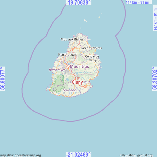
Cluny GPS coordinates[2]
20° 22' 0.984" South, 57° 36' 14.004" East
| Map corner | latitude | longitude |
|---|---|---|
| Upper-left | -19.70638°, | 56.90077° |
| Center: | -20.36694°, | 57.60389° |
| Lower-right: | -21.02469°, | 58.30702° |
| Map W x H: | 146.6×146.6 km | = 91.1×91.1mi |
| max Lat: | -10.38803° ⇑83.8% North |
| Cluny: | -20.36694° |
| min Lat: | ⇓16.2% South -20.51667° |
| min Long | Cluny | max Long |
| 56.61795° | 57.60389° | 63.41667° |
| W 53.5%⇐ | ⇒46.5% E |
Elevation
Elevation of Cluny is 317 m = 1040 ft, and this is 164.9 m = 541 ft above average elevation for this country.
| Max E: |
467 m = 1532 ft | 18.2% |
| Cluny | 317 m 1040 ft | |
| Avg. | 152.1 m = 499 ft | |
Min E: |
1 m = 3 ft | 81.8% |
See also: Mauritius elevation on elevation.city.
Geographical zone
Cluny is located in South Torrid zone (between Equator and Tropic of Capricorn). Distance of this Southern Tropic circle is 341.3 km =212.1 mi to South.| Distance of | km | miles | from Cluny |
|---|---|---|---|
| Equator | 2264.6 | 1407.2 | to North |
| Tropic Capricorn | 341.3 | 212.1 | to South |
| Antarctic Circle | 5136.6 | 3191.7 | to South |
| South Pole | 7742.5 | 4811 | to South |


Nearby cities:
15 places around Cluny: (largest is in red/bold)
• Bananes
2.8 km =1.7 mi,  324°
324°
• Beau Vallon
11.1 km =6.9 mi,  121°
121°
• Camp Diable
11 km =6.8 mi,  193°
193°
• Curepipe
9.9 km =6.2 mi,  304°
304°
• Dubreuil
7.3 km =4.5 mi,  355°
355°
• Grand Bois
8.5 km =5.3 mi,  227°
227°
• Mahébourg
11 km =6.8 mi,  114°
114°
• Melrose
11.2 km =7 mi,  15°
15°
• Midlands
6.4 km =4 mi,  326°
326°
• Montagne Blanche
10.7 km =6.6 mi,  32°
32°
• New Grove
4.7 km =2.9 mi,  167°
167°
• Nouvelle France
4.5 km =2.8 mi,  264°
264°
• Plaine Magnien
9.8 km =6.1 mi,  135°
135°
• Rose Belle
3.8 km =2.4 mi, 191°
• Saint Hubert
3.6 km =2.2 mi,  85°
85°
Sources, notices
• [Note1] Compared only with cities in Mauritius existing in our database
• [Src1] Map data: © OpenStreetMap contributors (CC-BY-SA)
• [Src2] Other city data from geonames.org with taken over terms of usage.
• [Src3] Geographical zone / Annual Mean Temperature by Robert A. Rohde @ Wikipedia
