Bananes geodata
Bananes (Grand Port) is a populated place; located in Mauritius in Indian/Mauritius (GMT+4) time zone. With population of 652 people, there are 97 cities with bigger population in this country. Compared to other cities in Mauritius, 79.8% of cities are located further ↑North; 53.5% of cities are located further →East and 92.9% of cities have lower elevation than Bananes. Note1


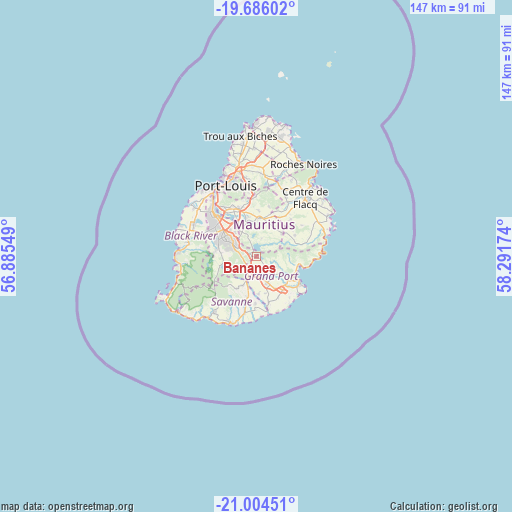
Bananes GPS coordinates[2]
20° 20' 48.012" South, 57° 35' 18.996" East
| Map corner | latitude | longitude |
|---|---|---|
| Upper-left | -19.68602°, | 56.88549° |
| Center: | -20.34667°, | 57.58861° |
| Lower-right: | -21.00451°, | 58.29174° |
| Map W x H: | 146.6×146.6 km | = 91.1×91.1mi |
| max Lat: | -10.38803° ⇑79.8% North |
| Bananes: | -20.34667° |
| min Lat: | ⇓20.2% South -20.51667° |
| min Long | Bananes | max Long |
| 56.61795° | 57.58861° | 63.41667° |
| W 46.5%⇐ | ⇒53.5% E |
Elevation
Elevation of Bananes is 402 m = 1319 ft, and this is 249.9 m = 820 ft above average elevation for this country.
| Max E: |
467 m = 1532 ft | 7.1% |
| Bananes | 402 m 1319 ft | |
| Avg. | 152.1 m = 499 ft | |
Min E: |
1 m = 3 ft | 92.9% |
See also: Mauritius elevation on elevation.city.
Geographical zone
Bananes is located in South Torrid zone (between Equator and Tropic of Capricorn). Distance of this Southern Tropic circle is 343.6 km =213.5 mi to South.| Distance of | km | miles | from Bananes |
|---|---|---|---|
| Equator | 2262.3 | 1405.7 | to North |
| Tropic Capricorn | 343.6 | 213.5 | to South |
| Antarctic Circle | 5138.8 | 3193.1 | to South |
| South Pole | 7744.7 | 4812.3 | to South |


Nearby cities:
15 places around Bananes: (largest is in red/bold)
• Cluny
2.8 km =1.7 mi,  144°
144°
• Curepipe
7.4 km =4.6 mi,  297°
297°
• Dagotière
11.7 km =7.3 mi,  346°
346°
• Dubreuil
5.1 km =3.2 mi,  11°
11°
• Grand Bois
9.3 km =5.8 mi,  209°
209°
• Melrose
9.7 km =6 mi,  27°
27°
• Midlands
3.6 km =2.2 mi,  327°
327°
• Montagne Blanche
10 km =6.2 mi,  46°
46°
• New Grove
7.4 km =4.6 mi,  159°
159°
• Nouvelle France
3.9 km =2.4 mi,  227°
227°
• Providence
11.6 km =7.2 mi, 12°
• Quartier Militaire
11 km =6.8 mi,  4°
4°
• Rose Belle
6 km =3.7 mi,  171°
171°
• Saint Hubert
5.5 km =3.4 mi,  110°
110°
• Sebastopol
12.1 km =7.5 mi,  58°
58°
Sources, notices
• [Note1] Compared only with cities in Mauritius existing in our database
• [Src1] Map data: © OpenStreetMap contributors (CC-BY-SA)
• [Src2] Other city data from geonames.org with taken over terms of usage.
• [Src3] Geographical zone / Annual Mean Temperature by Robert A. Rohde @ Wikipedia
