Laventure geodata
Laventure (Flacq) is a populated place; located in Mauritius in Indian/Mauritius (GMT+4) time zone. With population of 6,171 people, there are 40 cities with bigger population in this country. Compared to other cities in Mauritius, 68.7% of cities are located further ↓South; 75.8% of cities are located further ←West and 51.5% of cities have lower elevation than Laventure. Note1


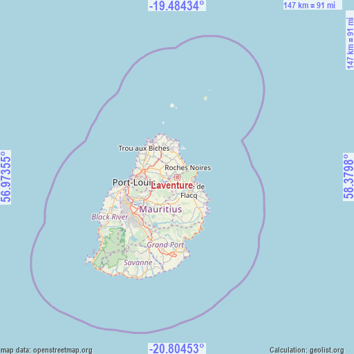
Laventure GPS coordinates[2]
20° 8' 44.988" South, 57° 40' 36.012" East
| Map corner | latitude | longitude |
|---|---|---|
| Upper-left | -19.48434°, | 56.97355° |
| Center: | -20.14583°, | 57.67667° |
| Lower-right: | -20.80453°, | 58.3798° |
| Map W x H: | 146.8×146.8 km | = 91.2×91.2mi |
| max Lat: | -10.38803° ⇑31.3% North |
| Laventure: | -20.14583° |
| min Lat: | ⇓68.7% South -20.51667° |
| min Long | Laventure | max Long |
| 56.61795° | 57.67667° | 63.41667° |
| W 75.8%⇐ | ⇒24.2% E |
Elevation
Elevation of Laventure is 120 m = 394 ft, and this is 32.1 m = 105 ft below average elevation for this country.
| Max E: |
467 m = 1532 ft | 48.5% |
| Avg. | 152.1 m = 499 ft | |
| Laventure | 120 m = 394 ft | |
Min E: |
1 m = 3 ft | 51.5% |
See also: Mauritius elevation on elevation.city.
Geographical zone
Laventure is located in South Torrid zone (between Equator and Tropic of Capricorn). Distance of this Southern Tropic circle is 365.9 km =227.4 mi to South.| Distance of | km | miles | from Laventure |
|---|---|---|---|
| Equator | 2240 | 1391.9 | to North |
| Tropic Capricorn | 365.9 | 227.4 | to South |
| Antarctic Circle | 5161.2 | 3207 | to South |
| South Pole | 7767.1 | 4826.3 | to South |


Nearby cities:
15 places around Laventure: (largest is in red/bold)
• Amaury
2.5 km =1.6 mi,  312°
312°
• Bon Accueil
3.5 km =2.2 mi,  217°
217°
• Brisée Verdière
3.7 km =2.3 mi,  237°
237°
• Centre de Flacq
6.3 km =3.9 mi,  141°
141°
• Congomah
9 km =5.6 mi,  267°
267°
• Espérance Trébuchet
9.2 km =5.7 mi,  336°
336°
• Lalmatie
5.1 km =3.2 mi,  198°
198°
• Mare La Chaux
9.6 km =6 mi,  127°
127°
• Piton
7.8 km =4.8 mi,  321°
321°
• Plaines des Roches
4.1 km =2.5 mi,  21°
21°
• Poste de Flacq
5.9 km =3.7 mi,  108°
108°
• Queen Victoria
8.9 km =5.5 mi,  158°
158°
• Rivière du Rempart
4.8 km =3 mi,  10°
10°
• Roches Noire
5.4 km =3.4 mi,  43°
43°
• Saint Julien
9.9 km =6.2 mi,  205°
205°
Sources, notices
• [Note1] Compared only with cities in Mauritius existing in our database
• [Src1] Map data: © OpenStreetMap contributors (CC-BY-SA)
• [Src2] Other city data from geonames.org with taken over terms of usage.
• [Src3] Geographical zone / Annual Mean Temperature by Robert A. Rohde @ Wikipedia
