Roches Noire geodata
Roches Noire (Rivière du Rempart) is a populated place; located in Mauritius in Indian/Mauritius (GMT+4) time zone. With population of 5,733 people, there are 47 cities with bigger population in this country. Compared to other cities in Mauritius, 76.8% of cities are located further ↓South; 83.8% of cities are located further ←West and 84.8% of cities have higher elevation than Roches Noire. Note1


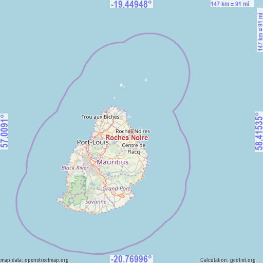
Roches Noire GPS coordinates[2]
20° 6' 39.996" South, 57° 42' 43.992" East
| Map corner | latitude | longitude |
|---|---|---|
| Upper-left | -19.44948°, | 57.0091° |
| Center: | -20.11111°, | 57.71222° |
| Lower-right: | -20.76996°, | 58.41535° |
| Map W x H: | 146.8×146.8 km | = 91.2×91.2mi |
| max Lat: | -10.38803° ⇑23.2% North |
| Roches Noire: | -20.11111° |
| min Lat: | ⇓76.8% South -20.51667° |
| min Long | Roches Noire | max Long |
| 56.61795° | 57.71222° | 63.41667° |
| W 83.8%⇐ | ⇒16.2% E |
Elevation
Elevation of Roches Noire is 23 m = 75 ft, and this is 129.1 m = 424 ft below average elevation for this country.
| Max E: |
467 m = 1532 ft | 84.8% |
| Avg. | 152.1 m = 499 ft | |
| Roches Noire | 23 m = 75 ft | |
Min E: |
1 m = 3 ft | 15.2% |
See also: Mauritius elevation on elevation.city.
Geographical zone
Roches Noire is located in South Torrid zone (between Equator and Tropic of Capricorn). Distance of this Southern Tropic circle is 369.8 km =229.8 mi to South.| Distance of | km | miles | from Roches Noire |
|---|---|---|---|
| Equator | 2236.1 | 1389.4 | to North |
| Tropic Capricorn | 369.8 | 229.8 | to South |
| Antarctic Circle | 5165 | 3209.4 | to South |
| South Pole | 7770.9 | 4828.6 | to South |


Nearby cities:
15 places around Roches Noire: (largest is in red/bold)
• Amaury
6 km =3.7 mi,  248°
248°
• Bon Accueil
8.8 km =5.5 mi,  221°
221°
• Brisée Verdière
9 km =5.6 mi,  229°
229°
• Centre de Flacq
8.7 km =5.4 mi,  178°
178°
• Cottage
10.4 km =6.5 mi,  303°
303°
• Espérance Trébuchet
8.7 km =5.4 mi, 302°
• Goodlands
10.3 km =6.4 mi,  321°
321°
• Lalmatie
10.2 km =6.3 mi,  211°
211°
• Laventure
5.4 km =3.4 mi, 223°
• Mare La Chaux
10.4 km =6.5 mi,  158°
158°
• Piton
8.9 km =5.5 mi,  285°
285°
• Plaines des Roches
2.2 km =1.4 mi,  268°
268°
• Poste de Flacq
6.1 km =3.8 mi, 161°
• Quatre Cocos
12 km =7.5 mi,  147°
147°
• Rivière du Rempart
3 km =1.9 mi, 287°
Sources, notices
• [Note1] Compared only with cities in Mauritius existing in our database
• [Src1] Map data: © OpenStreetMap contributors (CC-BY-SA)
• [Src2] Other city data from geonames.org with taken over terms of usage.
• [Src3] Geographical zone / Annual Mean Temperature by Robert A. Rohde @ Wikipedia
