Centre de Flacq geodata
Centre de Flacq (Flacq) is a seat of a first-order administrative division; located in Mauritius in Indian/Mauritius (GMT+4) time zone. With population of 17,710 people, there are 7 cities with bigger population in this country. Compared to other cities in Mauritius, 61.6% of cities are located further ↓South; 84.8% of cities are located further ←West and 70.7% of cities have higher elevation than Centre de Flacq. Note1


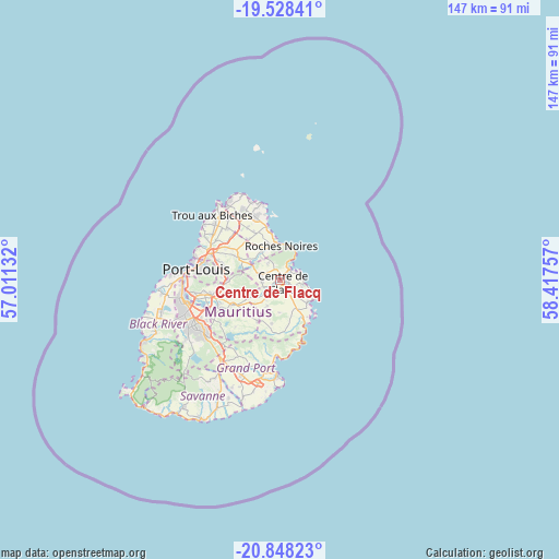
Centre de Flacq GPS coordinates[2]
20° 11' 22.992" South, 57° 42' 51.984" East
| Map corner | latitude | longitude |
|---|---|---|
| Upper-left | -19.52841°, | 57.01132° |
| Center: | -20.18972°, | 57.71444° |
| Lower-right: | -20.84823°, | 58.41757° |
| Map W x H: | 146.8×146.8 km | = 91.2×91.2mi |
| max Lat: | -10.38803° ⇑38.4% North |
| Centre de Flacq: | -20.18972° |
| min Lat: | ⇓61.6% South -20.51667° |
| min Long | Centre de Flacq | max Long |
| 56.61795° | 57.71444° | 63.41667° |
| W 84.8%⇐ | ⇒15.2% E |
Elevation
Elevation of Centre de Flacq is 53 m = 174 ft, and this is 99.1 m = 325 ft below average elevation for this country.
| Max E: |
467 m = 1532 ft | 70.7% |
| Avg. | 152.1 m = 499 ft | |
| Centre de Flacq | 53 m = 174 ft | |
Min E: |
1 m = 3 ft | 29.3% |
See also: Mauritius elevation on elevation.city.
Geographical zone
Centre de Flacq is located in South Torrid zone (between Equator and Tropic of Capricorn). Distance of this Southern Tropic circle is 361 km =224.3 mi to South.| Distance of | km | miles | from Centre de Flacq |
|---|---|---|---|
| Equator | 2244.9 | 1394.9 | to North |
| Tropic Capricorn | 361 | 224.3 | to South |
| Antarctic Circle | 5156.3 | 3204 | to South |
| South Pole | 7762.2 | 4823.2 | to South |


Nearby cities:
15 places around Centre de Flacq: (largest is in red/bold)
• Amaury
8.7 km =5.4 mi,  318°
318°
• Bel Air Rivière Sèche
8.4 km =5.2 mi,  154°
154°
• Bon Accueil
6.4 km =4 mi,  289°
289°
• Brisée Verdière
7.6 km =4.7 mi, 292°
• Camp Ithier
4.4 km =2.7 mi,  131°
131°
• Camp de Masque
7.5 km =4.7 mi,  225°
225°
• Clémencia
8.3 km =5.2 mi,  186°
186°
• Ecroignard
4.6 km =2.9 mi, 150°
• Lalmatie
5.6 km =3.5 mi,  270°
270°
• Laventure
6.3 km =3.9 mi, 321°
• Mare La Chaux
3.8 km =2.4 mi,  104°
104°
• Poste de Flacq
3.4 km =2.1 mi,  29°
29°
• Quatre Cocos
6.4 km =4 mi, 101°
• Queen Victoria
3.4 km =2.1 mi, 192°
• Roches Noire
8.7 km =5.4 mi,  358°
358°
Sources, notices
• [Note1] Compared only with cities in Mauritius existing in our database
• [Src1] Map data: © OpenStreetMap contributors (CC-BY-SA)
• [Src2] Other city data from geonames.org with taken over terms of usage.
• [Src3] Geographical zone / Annual Mean Temperature by Robert A. Rohde @ Wikipedia
