Mare La Chaux geodata
Mare La Chaux (Flacq) is a populated place; located in Mauritius in Indian/Mauritius (GMT+4) time zone. With population of 2,058 people, there are 84 cities with bigger population in this country. Compared to other cities in Mauritius, 57.6% of cities are located further ↓South; 90.9% of cities are located further ←West and 72.7% of cities have higher elevation than Mare La Chaux. Note1


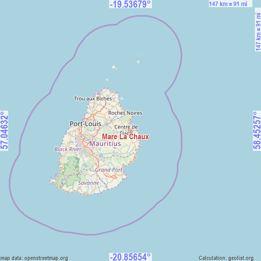
Mare La Chaux GPS coordinates[2]
20° 11' 53.016" South, 57° 44' 57.984" East
| Map corner | latitude | longitude |
|---|---|---|
| Upper-left | -19.53679°, | 57.04632° |
| Center: | -20.19806°, | 57.74944° |
| Lower-right: | -20.85654°, | 58.45257° |
| Map W x H: | 146.7×146.7 km | = 91.2×91.2mi |
| max Lat: | -10.38803° ⇑42.4% North |
| Mare La Chaux: | -20.19806° |
| min Lat: | ⇓57.6% South -20.51667° |
| min Long | Mare La Chaux | max Long |
| 56.61795° | 57.74944° | 63.41667° |
| W 90.9%⇐ | ⇒9.1% E |
Elevation
Elevation of Mare La Chaux is 50 m = 164 ft, and this is 102.1 m = 335 ft below average elevation for this country.
| Max E: |
467 m = 1532 ft | 72.7% |
| Avg. | 152.1 m = 499 ft | |
| Mare La Chaux | 50 m = 164 ft | |
Min E: |
1 m = 3 ft | 27.3% |
See also: Mauritius elevation on elevation.city.
Geographical zone
Mare La Chaux is located in South Torrid zone (between Equator and Tropic of Capricorn). Distance of this Southern Tropic circle is 360.1 km =223.8 mi to South.| Distance of | km | miles | from Mare La Chaux |
|---|---|---|---|
| Equator | 2245.8 | 1395.5 | to North |
| Tropic Capricorn | 360.1 | 223.8 | to South |
| Antarctic Circle | 5155.4 | 3203.4 | to South |
| South Pole | 7761.2 | 4822.6 | to South |


Nearby cities:
15 places around Mare La Chaux: (largest is in red/bold)
• Bel Air Rivière Sèche
6.6 km =4.1 mi,  179°
179°
• Bon Accueil
10.2 km =6.3 mi,  287°
287°
• Camp Ithier
2 km =1.2 mi,  191°
191°
• Camp de Masque
10 km =6.2 mi,  244°
244°
• Centre de Flacq
3.8 km =2.4 mi,  284°
284°
• Clémencia
8.6 km =5.3 mi,  211°
211°
• Ecroignard
3.4 km =2.1 mi,  204°
204°
• Grande Rivière Sud Est
10.2 km =6.3 mi,  164°
164°
• Lalmatie
9.3 km =5.8 mi, 275°
• Laventure
9.6 km =6 mi,  307°
307°
• Olivia
10.2 km =6.3 mi, 190°
• Poste de Flacq
4.4 km =2.7 mi,  333°
333°
• Quatre Cocos
2.6 km =1.6 mi,  98°
98°
• Queen Victoria
5 km =3.1 mi, 240°
• Roches Noire
10.4 km =6.5 mi,  338°
338°
Sources, notices
• [Note1] Compared only with cities in Mauritius existing in our database
• [Src1] Map data: © OpenStreetMap contributors (CC-BY-SA)
• [Src2] Other city data from geonames.org with taken over terms of usage.
• [Src3] Geographical zone / Annual Mean Temperature by Robert A. Rohde @ Wikipedia
