Matlapa geodata
Matlapa (San Luis Potosí) is a seat of a second-order administrative division; located in Mexico in America/Mexico_City (GMT-6) time zone. With population of 3,792 people, there are 2411 cities with bigger population in this country. Compared to other cities in Mexico, 80.4% of cities are located further ↓South; 53.2% of cities are located further ←West and 78% of cities have higher elevation than Matlapa. Note1


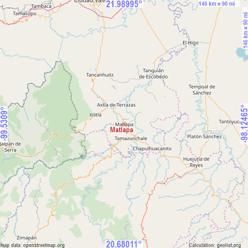
Matlapa GPS coordinates[2]
21° 20' 11.364" North, 98° 49' 39.972" West
| Map corner | latitude | longitude |
|---|---|---|
| Upper-left | 21.98995°, | -99.5309° |
| Center: | 21.33649°, | -98.82777° |
| Lower-right: | 20.68011°, | -98.12465° |
| Map W x H: | 145.6×145.6 km | = 90.5×90.5mi |
| max Lat: | 32.7° ⇑19.6% North |
| Matlapa: | 21.33649° |
| min Lat: | ⇓80.4% South 14.53588° |
| min Long | Matlapa | max Long |
| -117.105° | -98.82777° | -86.73105° |
| W 53.2%⇐ | ⇒46.8% E |
Elevation
Elevation of Matlapa is 131 m = 430 ft, and this is 1122.7 m = 3683 ft below average elevation for this country.
| Max E: |
3497 m = 11473 ft | 78% |
| Avg. | 1253.7 m = 4113 ft | |
| Matlapa | 131 m = 430 ft | |
Min E: |
-1 m = -3 ft | 22% |
See also: Mexico elevation on elevation.city.
Geographical zone
Matlapa is located in North Torrid zone (between Equator and Tropic of Cancer). Distance of this Northern Tropic circle is 233.5 km =145.1 mi to North.| Distance of | km | miles | from Matlapa |
|---|---|---|---|
| North Pole | 7634.7 | 4744 | to North |
| Arctic Circle | 5028.8 | 3124.8 | to North |
| Tropic Cancer | 233.5 | 145.1 | to North |
| Equator | 2372.4 | 1474.1 | to South |


Nearby cities:
15 places around Matlapa: (largest is in red/bold)
• Ahuehueyo
5.9 km =3.7 mi,  163°
163°
• Ahuehueyo Primero Centro
1.4 km =0.9 mi,  314°
314°
• Atlamaxátl
2.9 km =1.8 mi,  174°
174°
• Barrio de Arriba
0.5 km =0.3 mi,  196°
196°
• Barrio de En Medio
0.9 km =0.6 mi,  273°
273°
• Chalchocoyo
4.4 km =2.7 mi,  123°
123°
• Copalo (Chalco)
4.5 km =2.8 mi,  21°
21°
• Cuixcoatitla (Chalco)
3.6 km =2.2 mi,  32°
32°
• Las Cuevas
5.7 km =3.5 mi,  301°
301°
• Nexcuayo II
3.5 km =2.2 mi,  109°
109°
• Papatlas
4.5 km =2.8 mi,  41°
41°
• San Antonio
2 km =1.2 mi,  76°
76°
• Tepetzintla
3.5 km =2.2 mi, 168°
• Texquitote Primero
5.1 km =3.2 mi,  147°
147°
• Xochititla
3.3 km =2.1 mi, 145°
Sources, notices
• [Note1] Compared only with cities in Mexico existing in our database
• [Src1] Map data: © OpenStreetMap contributors (CC-BY-SA)
• [Src2] Other city data from geonames.org with taken over terms of usage.
• [Src3] Geographical zone / Annual Mean Temperature by Robert A. Rohde @ Wikipedia
