Tepetzintla geodata
Tepetzintla (San Luis Potosí) is a populated place; located in Mexico in America/Mexico_City (GMT-6) time zone. With population of 873 people, there are 10005 cities with bigger population in this country. Compared to other cities in Mexico, 80.1% of cities are located further ↓South; 53.3% of cities are located further ←West and 73.1% of cities have higher elevation than Tepetzintla. Note1


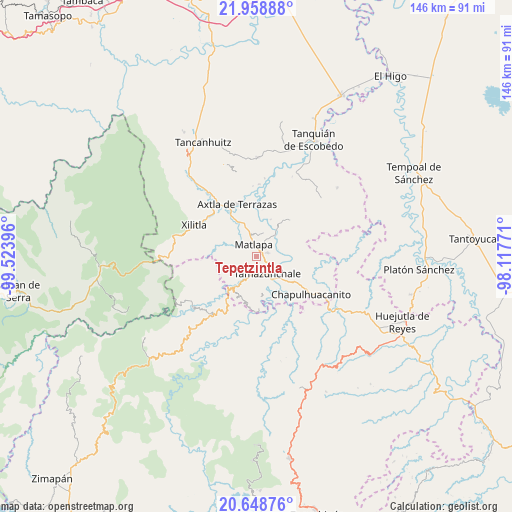
Tepetzintla GPS coordinates[2]
21° 18' 19.008" North, 98° 49' 14.988" West
| Map corner | latitude | longitude |
|---|---|---|
| Upper-left | 21.95888°, | -99.52396° |
| Center: | 21.30528°, | -98.82083° |
| Lower-right: | 20.64876°, | -98.11771° |
| Map W x H: | 145.7×145.7 km | = 90.5×90.5mi |
| max Lat: | 32.7° ⇑19.9% North |
| Tepetzintla: | 21.30528° |
| min Lat: | ⇓80.1% South 14.53588° |
| min Long | Tepetzintla | max Long |
| -117.105° | -98.82083° | -86.73105° |
| W 53.3%⇐ | ⇒46.7% E |
Elevation
Elevation of Tepetzintla is 285 m = 935 ft, and this is 968.7 m = 3178 ft below average elevation for this country.
| Max E: |
3497 m = 11473 ft | 73.1% |
| Avg. | 1253.7 m = 4113 ft | |
| Tepetzintla | 285 m = 935 ft | |
Min E: |
-1 m = -3 ft | 26.9% |
See also: Mexico elevation on elevation.city.
Geographical zone
Tepetzintla is located in North Torrid zone (between Equator and Tropic of Cancer). Distance of this Northern Tropic circle is 237 km =147.3 mi to North.| Distance of | km | miles | from Tepetzintla |
|---|---|---|---|
| North Pole | 7638.1 | 4746.1 | to North |
| Arctic Circle | 5032.2 | 3126.9 | to North |
| Tropic Cancer | 237 | 147.3 | to North |
| Equator | 2368.9 | 1472 | to South |


Nearby cities:
15 places around Tepetzintla: (largest is in red/bold)
• Ahuehueyo
2.4 km =1.5 mi,  155°
155°
• Ahuehueyo Primero Centro
4.7 km =2.9 mi,  338°
338°
• Atlamaxátl
0.8 km =0.5 mi,  323°
323°
• Barrio de Arriba
3.1 km =1.9 mi, 343°
• Barrio de En Medio
3.9 km =2.4 mi, 335°
• Chalchocoyo
3.2 km =2 mi,  71°
71°
• Coyol (Vega Larga)
5.4 km =3.4 mi,  217°
217°
• Cuixcuatitla
5.5 km =3.4 mi,  97°
97°
• Ixteamel
3.5 km =2.2 mi,  134°
134°
• Matlapa
3.5 km =2.2 mi,  348°
348°
• Nexcuayo II
3.5 km =2.2 mi,  48°
48°
• San Antonio
4.1 km =2.5 mi,  17°
17°
• Tacial
5.5 km =3.4 mi,  168°
168°
• Texquitote Primero
2.2 km =1.4 mi,  112°
112°
• Xochititla
1.4 km =0.9 mi,  56°
56°
Sources, notices
• [Note1] Compared only with cities in Mexico existing in our database
• [Src1] Map data: © OpenStreetMap contributors (CC-BY-SA)
• [Src2] Other city data from geonames.org with taken over terms of usage.
• [Src3] Geographical zone / Annual Mean Temperature by Robert A. Rohde @ Wikipedia
