La Purísima geodata
La Purísima (San Luis Potosí) is a populated place; located in Mexico in America/Mexico_City (GMT-6) time zone. With population of 628 people, there are 13781 cities with bigger population in this country. Compared to other cities in Mexico, 81.2% of cities are located further ↓South; 52.1% of cities are located further ←West and 79.3% of cities have higher elevation than La Purísima. Note1


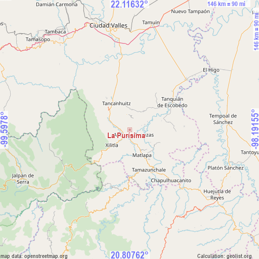
La Purísima GPS coordinates[2]
21° 27' 48.384" North, 98° 53' 40.812" West
| Map corner | latitude | longitude |
|---|---|---|
| Upper-left | 22.11632°, | -99.5978° |
| Center: | 21.46344°, | -98.89467° |
| Lower-right: | 20.80762°, | -98.19155° |
| Map W x H: | 145.5×145.5 km | = 90.4×90.4mi |
| max Lat: | 32.7° ⇑18.8% North |
| La Purísima: | 21.46344° |
| min Lat: | ⇓81.2% South 14.53588° |
| min Long | La Purísima | max Long |
| -117.105° | -98.89467° | -86.73105° |
| W 52.1%⇐ | ⇒47.9% E |
Elevation
Elevation of La Purísima is 106 m = 348 ft, and this is 1147.7 m = 3765 ft below average elevation for this country.
| Max E: |
3497 m = 11473 ft | 79.3% |
| Avg. | 1253.7 m = 4113 ft | |
| La Purísima | 106 m = 348 ft | |
Min E: |
-1 m = -3 ft | 20.7% |
See also: Mexico elevation on elevation.city.
Geographical zone
La Purísima is located in North Torrid zone (between Equator and Tropic of Cancer). Distance of this Northern Tropic circle is 219.4 km =136.3 mi to North.| Distance of | km | miles | from La Purísima |
|---|---|---|---|
| North Pole | 7620.6 | 4735.2 | to North |
| Arctic Circle | 5014.7 | 3116 | to North |
| Tropic Cancer | 219.4 | 136.3 | to North |
| Equator | 2386.5 | 1482.9 | to South |


Nearby cities:
15 places around La Purísima: (largest is in red/bold)
• Ahuacatitla
5.8 km =3.6 mi,  141°
141°
• Ajuatitla Primera Sección
5.9 km =3.7 mi,  347°
347°
• Amaxac
3.9 km =2.4 mi,  355°
355°
• Axtla de Terrazas
3.4 km =2.1 mi, 143°
• Chimalaco
4.7 km =2.9 mi,  266°
266°
• Coatzontitla
2.5 km =1.6 mi,  193°
193°
• Comunidad Calmecayo
7 km =4.3 mi,  17°
17°
• La Herradura
6.1 km =3.8 mi,  247°
247°
• Nuevo Ayotoxco
5.7 km =3.5 mi,  98°
98°
• Rancho Nuevo
4.3 km =2.7 mi,  257°
257°
• Tampochocho
3.8 km =2.4 mi,  41°
41°
• Tazaquil
5.6 km =3.5 mi,  303°
303°
• Tepotzuapa Primera Sección
3.7 km =2.3 mi, 300°
• Tlacuapa (Temascal)
7.1 km =4.4 mi,  227°
227°
• Xoloco
0.6 km =0.4 mi, 348°
Sources, notices
• [Note1] Compared only with cities in Mexico existing in our database
• [Src1] Map data: © OpenStreetMap contributors (CC-BY-SA)
• [Src2] Other city data from geonames.org with taken over terms of usage.
• [Src3] Geographical zone / Annual Mean Temperature by Robert A. Rohde @ Wikipedia
