Axtla de Terrazas geodata
Axtla de Terrazas (San Luis Potosí) is a seat of a second-order administrative division; located in Mexico in America/Mexico_City (GMT-6) time zone. With population of 7,714 people, there are 1208 cities with bigger population in this country. Compared to other cities in Mexico, 81.1% of cities are located further ↓South; 52.3% of cities are located further ←West and 80.6% of cities have higher elevation than Axtla de Terrazas. Note1


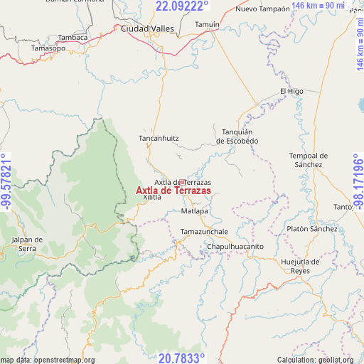
Axtla de Terrazas GPS coordinates[2]
21° 26' 21.228" North, 98° 52' 30.288" West
| Map corner | latitude | longitude |
|---|---|---|
| Upper-left | 22.09222°, | -99.57821° |
| Center: | 21.43923°, | -98.87508° |
| Lower-right: | 20.7833°, | -98.17196° |
| Map W x H: | 145.5×145.5 km | = 90.4×90.4mi |
| max Lat: | 32.7° ⇑18.9% North |
| Axtla de Terrazas: | 21.43923° |
| min Lat: | ⇓81.1% South 14.53588° |
| min Long | Axtla de Terraz | max Long |
| -117.105° | -98.87508° | -86.73105° |
| W 52.3%⇐ | ⇒47.7% E |
Elevation
Elevation of Axtla de Terrazas is 86 m = 282 ft, and this is 1167.7 m = 3831 ft below average elevation for this country.
| Max E: |
3497 m = 11473 ft | 80.6% |
| Avg. | 1253.7 m = 4113 ft | |
| Axtla de Terrazas | 86 m = 282 ft | |
Min E: |
-1 m = -3 ft | 19.4% |
See also: Mexico elevation on elevation.city.
Geographical zone
Axtla de Terrazas is located in North Torrid zone (between Equator and Tropic of Cancer). Distance of this Northern Tropic circle is 222.1 km =138 mi to North.| Distance of | km | miles | from Axtla de Terrazas |
|---|---|---|---|
| North Pole | 7623.2 | 4736.8 | to North |
| Arctic Circle | 5017.4 | 3117.7 | to North |
| Tropic Cancer | 222.1 | 138 | to North |
| Equator | 2383.8 | 1481.2 | to South |


Nearby cities:
15 places around Axtla de Terrazas: (largest is in red/bold)
• Ahuacatitla
2.5 km =1.6 mi,  138°
138°
• Amaxac
7 km =4.3 mi,  340°
340°
• Chimalaco
7.1 km =4.4 mi,  289°
289°
• Coatzontitla
2.6 km =1.6 mi,  275°
275°
• Hulero
7.5 km =4.7 mi,  89°
89°
• Jalpilla
4.8 km =3 mi,  176°
176°
• La Purísima
3.4 km =2.1 mi,  323°
323°
• Nuevo Ayotoxco
4 km =2.5 mi,  62°
62°
• Picholco
6.1 km =3.8 mi,  158°
158°
• Rancho Nuevo
6.5 km =4 mi, 285°
• Tampochocho
5.6 km =3.5 mi,  5°
5°
• Temalacaco
4.1 km =2.5 mi,  134°
134°
• Tenexio
7 km =4.3 mi, 183°
• Tepotzuapa Primera Sección
6.9 km =4.3 mi,  311°
311°
• Xoloco
3.9 km =2.4 mi,  326°
326°
Sources, notices
• [Note1] Compared only with cities in Mexico existing in our database
• [Src1] Map data: © OpenStreetMap contributors (CC-BY-SA)
• [Src2] Other city data from geonames.org with taken over terms of usage.
• [Src3] Geographical zone / Annual Mean Temperature by Robert A. Rohde @ Wikipedia
