Nuevo Ayotoxco geodata
Nuevo Ayotoxco (San Luis Potosí) is a populated place; located in Mexico in America/Mexico_City (GMT-6) time zone. With population of 570 people, there are 15008 cities with bigger population in this country. Compared to other cities in Mexico, 81.2% of cities are located further ↓South; 53% of cities are located further ←West and 81.3% of cities have higher elevation than Nuevo Ayotoxco. Note1


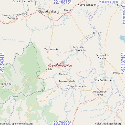
Nuevo Ayotoxco GPS coordinates[2]
21° 27' 20.988" North, 98° 50' 25.008" West
| Map corner | latitude | longitude |
|---|---|---|
| Upper-left | 22.10875°, | -99.54341° |
| Center: | 21.45583°, | -98.84028° |
| Lower-right: | 20.79998°, | -98.13716° |
| Map W x H: | 145.5×145.5 km | = 90.4×90.4mi |
| max Lat: | 32.7° ⇑18.8% North |
| Nuevo Ayotoxco: | 21.45583° |
| min Lat: | ⇓81.2% South 14.53588° |
| min Long | Nuevo Ayotoxco | max Long |
| -117.105° | -98.84028° | -86.73105° |
| W 53%⇐ | ⇒47% E |
Elevation
Elevation of Nuevo Ayotoxco is 78 m = 256 ft, and this is 1175.7 m = 3857 ft below average elevation for this country.
| Max E: |
3497 m = 11473 ft | 81.3% |
| Avg. | 1253.7 m = 4113 ft | |
| Nuevo Ayotoxco | 78 m = 256 ft | |
Min E: |
-1 m = -3 ft | 18.7% |
See also: Mexico elevation on elevation.city.
Geographical zone
Nuevo Ayotoxco is located in North Torrid zone (between Equator and Tropic of Cancer). Distance of this Northern Tropic circle is 220.3 km =136.9 mi to North.| Distance of | km | miles | from Nuevo Ayotoxco |
|---|---|---|---|
| North Pole | 7621.4 | 4735.7 | to North |
| Arctic Circle | 5015.5 | 3116.5 | to North |
| Tropic Cancer | 220.3 | 136.9 | to North |
| Equator | 2385.7 | 1482.4 | to South |


Nearby cities:
15 places around Nuevo Ayotoxco: (largest is in red/bold)
• Ahuacatitla
4.2 km =2.6 mi,  208°
208°
• Amaxac
7.6 km =4.7 mi,  308°
308°
• Axtla de Terrazas
4 km =2.5 mi,  242°
242°
• Coatzontitla
6.4 km =4 mi,  255°
255°
• Comunidad Calmecayo
8.3 km =5.2 mi,  335°
335°
• Ensenada (Chalco)
8.5 km =5.3 mi,  151°
151°
• Hulero
4.3 km =2.7 mi,  114°
114°
• Jalpilla
7.5 km =4.7 mi, 206°
• La Purísima
5.7 km =3.5 mi,  278°
278°
• Las Mesas
8 km =5 mi,  349°
349°
• Picholco
7.7 km =4.8 mi,  190°
190°
• Tampochocho
4.8 km =3 mi,  320°
320°
• Temalacaco
4.7 km =2.9 mi, 188°
• Tonatico
4.8 km =3 mi,  36°
36°
• Xoloco
5.9 km =3.7 mi, 284°
Sources, notices
• [Note1] Compared only with cities in Mexico existing in our database
• [Src1] Map data: © OpenStreetMap contributors (CC-BY-SA)
• [Src2] Other city data from geonames.org with taken over terms of usage.
• [Src3] Geographical zone / Annual Mean Temperature by Robert A. Rohde @ Wikipedia
