Santa Martha geodata
Santa Martha (San Luis Potosí) is a populated place; located in Mexico in America/Mexico_City (GMT-6) time zone. With population of 808 people, there are 10815 cities with bigger population in this country. Compared to other cities in Mexico, 82.1% of cities are located further ↓South; 54.4% of cities are located further ←West and 77.9% of cities have higher elevation than Santa Martha. Note1


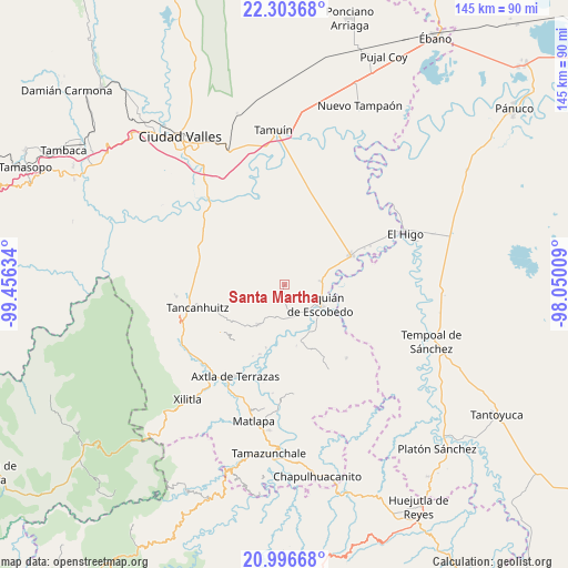
Santa Martha GPS coordinates[2]
21° 39' 5.976" North, 98° 45' 11.556" West
| Map corner | latitude | longitude |
|---|---|---|
| Upper-left | 22.30368°, | -99.45634° |
| Center: | 21.65166°, | -98.75321° |
| Lower-right: | 20.99668°, | -98.05009° |
| Map W x H: | 145.3×145.3 km | = 90.3×90.3mi |
| max Lat: | 32.7° ⇑17.9% North |
| Santa Martha: | 21.65166° |
| min Lat: | ⇓82.1% South 14.53588° |
| min Long | Santa Martha | max Long |
| -117.105° | -98.75321° | -86.73105° |
| W 54.4%⇐ | ⇒45.6% E |
Elevation
Elevation of Santa Martha is 132 m = 433 ft, and this is 1121.7 m = 3680 ft below average elevation for this country.
| Max E: |
3497 m = 11473 ft | 77.9% |
| Avg. | 1253.7 m = 4113 ft | |
| Santa Martha | 132 m = 433 ft | |
Min E: |
-1 m = -3 ft | 22.1% |
See also: Mexico elevation on elevation.city.
Geographical zone
Santa Martha is located in North Torrid zone (between Equator and Tropic of Cancer). Distance of this Northern Tropic circle is 198.5 km =123.3 mi to North.| Distance of | km | miles | from Santa Martha |
|---|---|---|---|
| North Pole | 7599.6 | 4722.2 | to North |
| Arctic Circle | 4993.7 | 3102.9 | to North |
| Tropic Cancer | 198.5 | 123.3 | to North |
| Equator | 2407.4 | 1495.9 | to South |


Nearby cities:
15 places around Santa Martha: (largest is in red/bold)
• Coromohom (Tocoymohom)
14.4 km =8.9 mi,  281°
281°
• Ejido el Barrancón
11.3 km =7 mi, 281°
• El Carrizal
5.4 km =3.4 mi,  171°
171°
• El Fortín May
10.5 km =6.5 mi,  301°
301°
• Las Lomas
6.1 km =3.8 mi,  107°
107°
• Lejem
12.6 km =7.8 mi,  248°
248°
• Nuevo Cueytzén
13.3 km =8.3 mi,  291°
291°
• Sagrada Familia
9.4 km =5.8 mi,  85°
85°
• San Francisco Cuayalab
9.7 km =6 mi,  22°
22°
• San Nicolás
3.8 km =2.4 mi,  318°
318°
• Santa Elena
8.4 km =5.2 mi,  61°
61°
• Tampamolón Corona
12.3 km =7.6 mi,  213°
213°
• Tanlajás
13.8 km =8.6 mi, 276°
• Tanquián de Escobedo
10.6 km =6.6 mi,  118°
118°
• Tocoy
12.2 km =7.6 mi,  263°
263°
Sources, notices
• [Note1] Compared only with cities in Mexico existing in our database
• [Src1] Map data: © OpenStreetMap contributors (CC-BY-SA)
• [Src2] Other city data from geonames.org with taken over terms of usage.
• [Src3] Geographical zone / Annual Mean Temperature by Robert A. Rohde @ Wikipedia
