Ejido el Barrancón geodata
Ejido el Barrancón (San Luis Potosí) is a populated place; located in Mexico in America/Mexico_City (GMT-6) time zone. With population of 608 people, there are 14173 cities with bigger population in this country. Compared to other cities in Mexico, 82.3% of cities are located further ↓South; 52.6% of cities are located further ←West and 80.4% of cities have higher elevation than Ejido el Barrancón. Note1


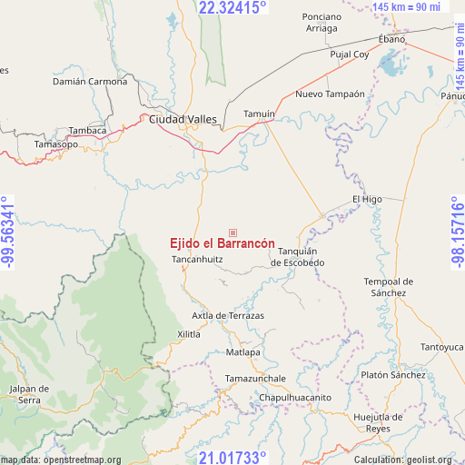
Ejido el Barrancón GPS coordinates[2]
21° 40' 19.992" North, 98° 51' 37.008" West
| Map corner | latitude | longitude |
|---|---|---|
| Upper-left | 22.32415°, | -99.56341° |
| Center: | 21.67222°, | -98.86028° |
| Lower-right: | 21.01733°, | -98.15716° |
| Map W x H: | 145.3×145.3 km | = 90.3×90.3mi |
| max Lat: | 32.7° ⇑17.7% North |
| Ejido el Barrancón: | 21.67222° |
| min Lat: | ⇓82.3% South 14.53588° |
| min Long | Ejido el Barran | max Long |
| -117.105° | -98.86028° | -86.73105° |
| W 52.6%⇐ | ⇒47.4% E |
Elevation
Elevation of Ejido el Barrancón is 89 m = 292 ft, and this is 1164.7 m = 3821 ft below average elevation for this country.
| Max E: |
3497 m = 11473 ft | 80.4% |
| Avg. | 1253.7 m = 4113 ft | |
| Ejido el Barrancón | 89 m = 292 ft | |
Min E: |
-1 m = -3 ft | 19.6% |
See also: Mexico elevation on elevation.city.
Geographical zone
Ejido el Barrancón is located in North Torrid zone (between Equator and Tropic of Cancer). Distance of this Northern Tropic circle is 196.2 km =121.9 mi to North.| Distance of | km | miles | from Ejido el Barrancón |
|---|---|---|---|
| North Pole | 7597.3 | 4720.7 | to North |
| Arctic Circle | 4991.4 | 3101.5 | to North |
| Tropic Cancer | 196.2 | 121.9 | to North |
| Equator | 2409.7 | 1497.3 | to South |


Nearby cities:
15 places around Ejido el Barrancón: (largest is in red/bold)
• Coaxinquila
12.7 km =7.9 mi,  180°
180°
• Coromohom (Tocoymohom)
3.1 km =1.9 mi,  282°
282°
• Ejido San José Xilatzén
7 km =4.3 mi,  272°
272°
• El Fortín May
3.9 km =2.4 mi,  33°
33°
• Las Armas
11.4 km =7.1 mi, 283°
• Lejem
7 km =4.3 mi,  185°
185°
• Nuevo Cueytzén
2.9 km =1.8 mi,  333°
333°
• San Antonio
7.3 km =4.5 mi,  217°
217°
• San José Pequetzén
11.3 km =7 mi,  245°
245°
• San Nicolás
8.5 km =5.3 mi,  86°
86°
• Santa Martha
11.3 km =7 mi,  101°
101°
• Tampamolón Corona
13.3 km =8.3 mi,  161°
161°
• Tan Jajnec
5.4 km =3.4 mi, 220°
• Tanlajás
2.8 km =1.7 mi, 253°
• Tocoy
3.9 km =2.4 mi,  196°
196°
Sources, notices
• [Note1] Compared only with cities in Mexico existing in our database
• [Src1] Map data: © OpenStreetMap contributors (CC-BY-SA)
• [Src2] Other city data from geonames.org with taken over terms of usage.
• [Src3] Geographical zone / Annual Mean Temperature by Robert A. Rohde @ Wikipedia
