El Carrizal geodata
El Carrizal (San Luis Potosí) is a populated place; located in Mexico in America/Mexico_City (GMT-6) time zone. With population of 666 people, there are 13039 cities with bigger population in this country. Compared to other cities in Mexico, 81.9% of cities are located further ↓South; 54.5% of cities are located further ←West and 81.5% of cities have higher elevation than El Carrizal. Note1


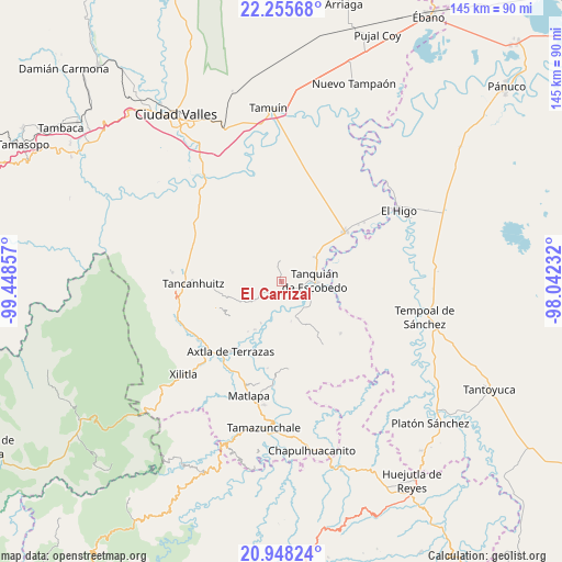
El Carrizal GPS coordinates[2]
21° 36' 12.384" North, 98° 44' 43.584" West
| Map corner | latitude | longitude |
|---|---|---|
| Upper-left | 22.25568°, | -99.44857° |
| Center: | 21.60344°, | -98.74544° |
| Lower-right: | 20.94824°, | -98.04232° |
| Map W x H: | 145.4×145.4 km | = 90.3×90.3mi |
| max Lat: | 32.7° ⇑18.1% North |
| El Carrizal: | 21.60344° |
| min Lat: | ⇓81.9% South 14.53588° |
| min Long | El Carrizal | max Long |
| -117.105° | -98.74544° | -86.73105° |
| W 54.5%⇐ | ⇒45.5% E |
Elevation
Elevation of El Carrizal is 76 m = 249 ft, and this is 1177.7 m = 3864 ft below average elevation for this country.
| Max E: |
3497 m = 11473 ft | 81.5% |
| Avg. | 1253.7 m = 4113 ft | |
| El Carrizal | 76 m = 249 ft | |
Min E: |
-1 m = -3 ft | 18.5% |
See also: Mexico elevation on elevation.city.
Geographical zone
El Carrizal is located in North Torrid zone (between Equator and Tropic of Cancer). Distance of this Northern Tropic circle is 203.8 km =126.6 mi to North.| Distance of | km | miles | from El Carrizal |
|---|---|---|---|
| North Pole | 7605 | 4725.5 | to North |
| Arctic Circle | 4999.1 | 3106.3 | to North |
| Tropic Cancer | 203.8 | 126.6 | to North |
| Equator | 2402.1 | 1492.6 | to South |


Nearby cities:
15 places around El Carrizal: (largest is in red/bold)
• Coaxinquila
13.1 km =8.1 mi,  247°
247°
• Ejido el Barrancón
14.1 km =8.8 mi,  302°
302°
• El Fortín May
14.6 km =9.1 mi,  318°
318°
• Las Lomas
6.1 km =3.8 mi,  55°
55°
• Las Mesas
14.1 km =8.8 mi,  232°
232°
• Lejem
12.5 km =7.8 mi,  273°
273°
• Sagrada Familia
10.5 km =6.5 mi,  54°
54°
• San Francisco Cuayalab
14.6 km =9.1 mi,  11°
11°
• San Nicolás
8.9 km =5.5 mi,  337°
337°
• Santa Elena
11.5 km =7.1 mi,  35°
35°
• Santa Martha
5.4 km =3.4 mi,  351°
351°
• Tampamolón Corona
9.1 km =5.7 mi,  236°
236°
• Tanquián de Escobedo
8.6 km =5.3 mi,  88°
88°
• Tocoy
13.5 km =8.4 mi,  286°
286°
• Tonatico
14.3 km =8.9 mi,  209°
209°
Sources, notices
• [Note1] Compared only with cities in Mexico existing in our database
• [Src1] Map data: © OpenStreetMap contributors (CC-BY-SA)
• [Src2] Other city data from geonames.org with taken over terms of usage.
• [Src3] Geographical zone / Annual Mean Temperature by Robert A. Rohde @ Wikipedia
