Zocea geodata
Zocea (Hidalgo) is a populated place; located in Mexico in America/Mexico_City (GMT-6) time zone. With population of 1,311 people, there are 6619 cities with bigger population in this country. Compared to other cities in Mexico, 66.4% of cities are located further ↓South; 55% of cities are located further →East and 67.9% of cities have lower elevation than Zocea. Note1


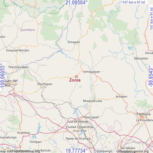
Zocea GPS coordinates[2]
20° 26' 15.36" North, 99° 21' 26.712" West
| Map corner | latitude | longitude |
|---|---|---|
| Upper-left | 21.09504°, | -100.06055° |
| Center: | 20.4376°, | -99.35742° |
| Lower-right: | 19.77734°, | -98.6543° |
| Map W x H: | 146.5×146.5 km | = 91×91mi |
| max Lat: | 32.7° ⇑33.6% North |
| Zocea: | 20.4376° |
| min Lat: | ⇓66.4% South 14.53588° |
| min Long | Zocea | max Long |
| -117.105° | -99.35742° | -86.73105° |
| W 45%⇐ | ⇒55% E |
Elevation
Elevation of Zocea is 1887 m = 6191 ft, and this is 633.3 m = 2078 ft above average elevation for this country.
| Max E: |
3497 m = 11473 ft | 32.1% |
| Zocea | 1887 m 6191 ft | |
| Avg. | 1253.7 m = 4113 ft | |
Min E: |
-1 m = -3 ft | 67.9% |
See also: Mexico elevation on elevation.city.
Geographical zone
Zocea is located in North Torrid zone (between Equator and Tropic of Cancer). Distance of this Northern Tropic circle is 333.5 km =207.2 mi to North.| Distance of | km | miles | from Zocea |
|---|---|---|---|
| North Pole | 7734.6 | 4806.1 | to North |
| Arctic Circle | 5128.7 | 3186.8 | to North |
| Tropic Cancer | 333.5 | 207.2 | to North |
| Equator | 2272.4 | 1412 | to South |


Nearby cities:
15 places around Zocea: (largest is in red/bold)
• Alfajayucan
3.4 km =2.1 mi,  164°
164°
• Boxtho
5 km =3.1 mi,  192°
192°
• Caltimacan
11.1 km =6.9 mi,  353°
353°
• Danghu
7.7 km =4.8 mi,  7°
7°
• El Deca
9.3 km =5.8 mi,  61°
61°
• El Espíritu
1.8 km =1.1 mi, 188°
• Ignacio López Rayón
10.5 km =6.5 mi, 59°
• La Huapilla
2.3 km =1.4 mi,  222°
222°
• La Vega
6.7 km =4.2 mi,  25°
25°
• Panales
10.1 km =6.3 mi,  69°
69°
• Portezuelo
7.7 km =4.8 mi,  44°
44°
• San Pablo Oxtotipan
11 km =6.8 mi, 191°
• Santa María Xigui
2.9 km =1.8 mi, 26°
• Santiago Ixtlahuaca
7.8 km =4.8 mi, 29°
• Yonthe Chico
4.5 km =2.8 mi,  136°
136°
Sources, notices
• [Note1] Compared only with cities in Mexico existing in our database
• [Src1] Map data: © OpenStreetMap contributors (CC-BY-SA)
• [Src2] Other city data from geonames.org with taken over terms of usage.
• [Src3] Geographical zone / Annual Mean Temperature by Robert A. Rohde @ Wikipedia
