Zaragoza geodata
Zaragoza (Puebla) is a populated place; located in Mexico in America/Mexico_City (GMT-6) time zone. With population of 10,743 people, there are 886 cities with bigger population in this country. Compared to other cities in Mexico, 52% of cities are located further ↓South; 68.9% of cities are located further ←West and 87.1% of cities have lower elevation than Zaragoza. Note1


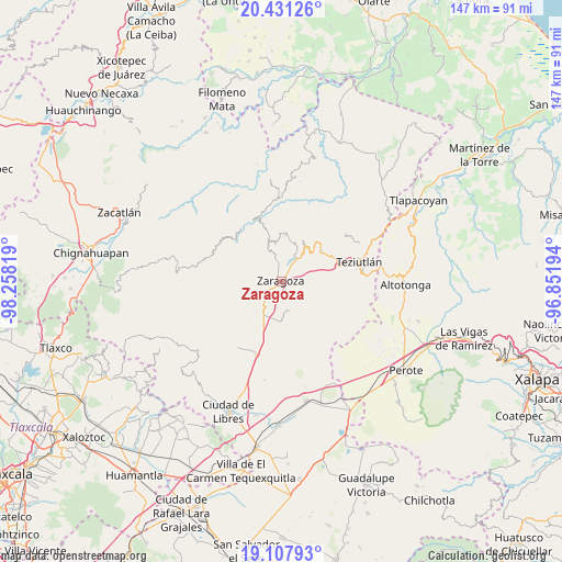
Zaragoza GPS coordinates[2]
19° 46' 15.492" North, 97° 33' 18.216" West
| Map corner | latitude | longitude |
|---|---|---|
| Upper-left | 20.43126°, | -98.25819° |
| Center: | 19.77097°, | -97.55506° |
| Lower-right: | 19.10793°, | -96.85194° |
| Map W x H: | 147.1×147.1 km | = 91.4×91.4mi |
| max Lat: | 32.7° ⇑48% North |
| Zaragoza: | 19.77097° |
| min Lat: | ⇓52% South 14.53588° |
| min Long | Zaragoza | max Long |
| -117.105° | -97.55506° | -86.73105° |
| W 68.9%⇐ | ⇒31.1% E |
Elevation
Elevation of Zaragoza is 2311 m = 7582 ft, and this is 1057.3 m = 3469 ft above average elevation for this country.
| Max E: |
3497 m = 11473 ft | 12.9% |
| Zaragoza | 2311 m 7582 ft | |
| Avg. | 1253.7 m = 4113 ft | |
Min E: |
-1 m = -3 ft | 87.1% |
See also: Mexico elevation on elevation.city.
Geographical zone
Zaragoza is located in North Torrid zone (between Equator and Tropic of Cancer). Distance of this Northern Tropic circle is 407.6 km =253.3 mi to North.| Distance of | km | miles | from Zaragoza |
|---|---|---|---|
| North Pole | 7808.7 | 4852.1 | to North |
| Arctic Circle | 5202.8 | 3232.9 | to North |
| Tropic Cancer | 407.6 | 253.3 | to North |
| Equator | 2198.3 | 1366 | to South |


Nearby cities:
15 places around Zaragoza: (largest is in red/bold)
• Acuaco
1.4 km =0.9 mi,  226°
226°
• Cuautlamingo
2 km =1.2 mi,  114°
114°
• El Molino
5.4 km =3.4 mi,  330°
330°
• Francisco I. Madero
4.9 km =3 mi,  303°
303°
• Ixmatlaco
6.1 km =3.8 mi,  173°
173°
• La Libertad
5.7 km =3.5 mi,  252°
252°
• Las Trancas
5 km =3.1 mi,  205°
205°
• Morelos
3 km =1.9 mi, 232°
• Nexticapan
6.3 km =3.9 mi,  0°
0°
• Ocotlán de Betancourt
3.5 km =2.2 mi,  33°
33°
• Plan de Guadalupe
3.9 km =2.4 mi,  6°
6°
• San José Buenavista
1.1 km =0.7 mi,  285°
285°
• Tepeteno de Iturbide
6.7 km =4.2 mi,  65°
65°
• Texocoyohuac
3.8 km =2.4 mi,  281°
281°
• Xonocuautla
4.5 km =2.8 mi,  64°
64°
Sources, notices
• [Note1] Compared only with cities in Mexico existing in our database
• [Src1] Map data: © OpenStreetMap contributors (CC-BY-SA)
• [Src2] Other city data from geonames.org with taken over terms of usage.
• [Src3] Geographical zone / Annual Mean Temperature by Robert A. Rohde @ Wikipedia
