Acuaco geodata
Acuaco (Puebla) is a populated place; located in Mexico in America/Mexico_City (GMT-6) time zone. With population of 1,071 people, there are 8151 cities with bigger population in this country. Compared to other cities in Mexico, 51.7% of cities are located further ↓South; 68.8% of cities are located further ←West and 86.5% of cities have lower elevation than Acuaco. Note1


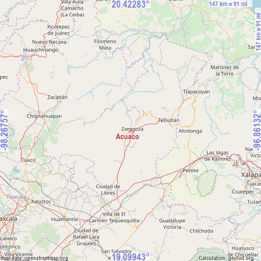
Acuaco GPS coordinates[2]
19° 45' 45" North, 97° 33' 51.984" West
| Map corner | latitude | longitude |
|---|---|---|
| Upper-left | 20.42283°, | -98.26757° |
| Center: | 19.7625°, | -97.56444° |
| Lower-right: | 19.09943°, | -96.86132° |
| Map W x H: | 147.1×147.2 km | = 91.4×91.5mi |
| max Lat: | 32.7° ⇑48.3% North |
| Acuaco: | 19.7625° |
| min Lat: | ⇓51.7% South 14.53588° |
| min Long | Acuaco | max Long |
| -117.105° | -97.56444° | -86.73105° |
| W 68.8%⇐ | ⇒31.2% E |
Elevation
Elevation of Acuaco is 2296 m = 7533 ft, and this is 1042.3 m = 3420 ft above average elevation for this country.
| Max E: |
3497 m = 11473 ft | 13.5% |
| Acuaco | 2296 m 7533 ft | |
| Avg. | 1253.7 m = 4113 ft | |
Min E: |
-1 m = -3 ft | 86.5% |
See also: Mexico elevation on elevation.city.
Geographical zone
Acuaco is located in North Torrid zone (between Equator and Tropic of Cancer). Distance of this Northern Tropic circle is 408.5 km =253.8 mi to North.| Distance of | km | miles | from Acuaco |
|---|---|---|---|
| North Pole | 7809.7 | 4852.7 | to North |
| Arctic Circle | 5203.8 | 3233.5 | to North |
| Tropic Cancer | 408.5 | 253.8 | to North |
| Equator | 2197.4 | 1365.4 | to South |


Nearby cities:
15 places around Acuaco: (largest is in red/bold)
• Cuautlamingo
2.8 km =1.7 mi,  87°
87°
• El Molino
5.9 km =3.7 mi,  343°
343°
• Francisco I. Madero
4.8 km =3 mi,  319°
319°
• Huitzitzilapan
6.8 km =4.2 mi,  194°
194°
• Ixmatlaco
5.4 km =3.4 mi,  162°
162°
• La Libertad
4.5 km =2.8 mi,  260°
260°
• Las Trancas
3.7 km =2.3 mi,  198°
198°
• Morelos
1.6 km =1 mi,  237°
237°
• Ocotlán de Betancourt
4.9 km =3 mi,  36°
36°
• Plan de Guadalupe
5 km =3.1 mi,  16°
16°
• San Francisco del Progreso
5.9 km =3.7 mi,  231°
231°
• San José Buenavista
1.2 km =0.7 mi,  355°
355°
• Texocoyohuac
3.2 km =2 mi,  302°
302°
• Xonocuautla
5.8 km =3.6 mi,  59°
59°
• Zaragoza
1.4 km =0.9 mi,  46°
46°
Sources, notices
• [Note1] Compared only with cities in Mexico existing in our database
• [Src1] Map data: © OpenStreetMap contributors (CC-BY-SA)
• [Src2] Other city data from geonames.org with taken over terms of usage.
• [Src3] Geographical zone / Annual Mean Temperature by Robert A. Rohde @ Wikipedia
