Morelos geodata
Morelos (Puebla) is a populated place; located in Mexico in America/Mexico_City (GMT-6) time zone. With population of 1,409 people, there are 6137 cities with bigger population in this country. Compared to other cities in Mexico, 51.6% of cities are located further ↓South; 68.7% of cities are located further ←West and 87.8% of cities have lower elevation than Morelos. Note1


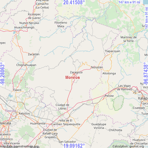
Morelos GPS coordinates[2]
19° 45' 16.992" North, 97° 34' 39" West
| Map corner | latitude | longitude |
|---|---|---|
| Upper-left | 20.41508°, | -98.28063° |
| Center: | 19.75472°, | -97.5775° |
| Lower-right: | 19.09162°, | -96.87438° |
| Map W x H: | 147.2×147.2 km | = 91.5×91.5mi |
| max Lat: | 32.7° ⇑48.4% North |
| Morelos: | 19.75472° |
| min Lat: | ⇓51.6% South 14.53588° |
| min Long | Morelos | max Long |
| -117.105° | -97.5775° | -86.73105° |
| W 68.7%⇐ | ⇒31.3% E |
Elevation
Elevation of Morelos is 2336 m = 7664 ft, and this is 1082.3 m = 3551 ft above average elevation for this country.
| Max E: |
3497 m = 11473 ft | 12.2% |
| Morelos | 2336 m 7664 ft | |
| Avg. | 1253.7 m = 4113 ft | |
Min E: |
-1 m = -3 ft | 87.8% |
See also: Mexico elevation on elevation.city.
Geographical zone
Morelos is located in North Torrid zone (between Equator and Tropic of Cancer). Distance of this Northern Tropic circle is 409.4 km =254.4 mi to North.| Distance of | km | miles | from Morelos |
|---|---|---|---|
| North Pole | 7810.5 | 4853.2 | to North |
| Arctic Circle | 5204.7 | 3234 | to North |
| Tropic Cancer | 409.4 | 254.4 | to North |
| Equator | 2196.5 | 1364.8 | to South |


Nearby cities:
15 places around Morelos: (largest is in red/bold)
• Acuaco
1.6 km =1 mi,  57°
57°
• Cuautlamingo
4.3 km =2.7 mi,  76°
76°
• El Molino
6.5 km =4 mi,  357°
357°
• Francisco I. Madero
4.8 km =3 mi,  338°
338°
• Huitzitzilapan
5.7 km =3.5 mi,  183°
183°
• Ixmatlaco
5.2 km =3.2 mi,  145°
145°
• La Libertad
3.1 km =1.9 mi,  272°
272°
• Las Trancas
2.7 km =1.7 mi, 175°
• Ocotlán de Betancourt
6.4 km =4 mi,  41°
41°
• Plan de Guadalupe
6.3 km =3.9 mi,  25°
25°
• San Francisco del Progreso
4.3 km =2.7 mi,  229°
229°
• San José Buenavista
2.5 km =1.6 mi, 31°
• San Miguel Tenextatiloyan
5.4 km =3.4 mi,  202°
202°
• Texocoyohuac
2.9 km =1.8 mi,  332°
332°
• Zaragoza
3 km =1.9 mi,  52°
52°
Sources, notices
• [Note1] Compared only with cities in Mexico existing in our database
• [Src1] Map data: © OpenStreetMap contributors (CC-BY-SA)
• [Src2] Other city data from geonames.org with taken over terms of usage.
• [Src3] Geographical zone / Annual Mean Temperature by Robert A. Rohde @ Wikipedia
