Zapoapan de Amapan geodata
Zapoapan de Amapan (Veracruz) is a populated place; located in Mexico in America/Mexico_City (GMT-6) time zone. With population of 1,043 people, there are 8357 cities with bigger population in this country. Compared to other cities in Mexico, 75.7% of cities are located further ↑North; 84% of cities are located further ←West and 84.3% of cities have higher elevation than Zapoapan de Amapan. Note1


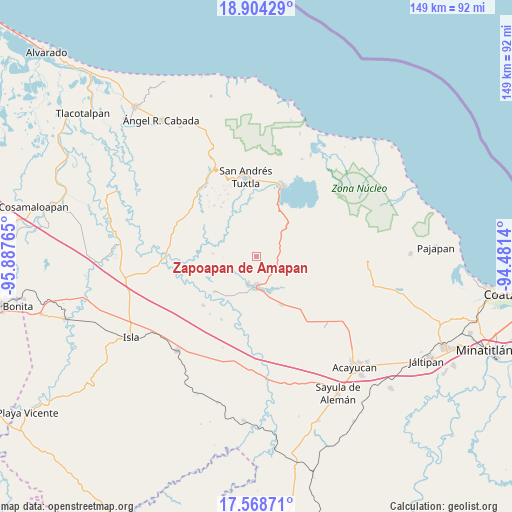
Zapoapan de Amapan GPS coordinates[2]
18° 14' 16.008" North, 95° 11' 4.272" West
| Map corner | latitude | longitude |
|---|---|---|
| Upper-left | 18.90429°, | -95.88765° |
| Center: | 18.23778°, | -95.18452° |
| Lower-right: | 17.56871°, | -94.4814° |
| Map W x H: | 148.5×148.5 km | = 92.3×92.3mi |
| max Lat: | 32.7° ⇑75.7% North |
| Zapoapan de Amapan: | 18.23778° |
| min Lat: | ⇓24.3% South 14.53588° |
| min Long | Zapoapan de Ama | max Long |
| -117.105° | -95.18452° | -86.73105° |
| W 84%⇐ | ⇒16% E |
Elevation
Elevation of Zapoapan de Amapan is 50 m = 164 ft, and this is 1203.7 m = 3949 ft below average elevation for this country.
| Max E: |
3497 m = 11473 ft | 84.3% |
| Avg. | 1253.7 m = 4113 ft | |
| Zapoapan de Amapan | 50 m = 164 ft | |
Min E: |
-1 m = -3 ft | 15.7% |
See also: Mexico elevation on elevation.city.
Geographical zone
Zapoapan de Amapan is located in North Torrid zone (between Equator and Tropic of Cancer). Distance of this Northern Tropic circle is 578.1 km =359.2 mi to North.| Distance of | km | miles | from Zapoapan de Amapan |
|---|---|---|---|
| North Pole | 7979.2 | 4958 | to North |
| Arctic Circle | 5373.3 | 3338.8 | to North |
| Tropic Cancer | 578.1 | 359.2 | to North |
| Equator | 2027.9 | 1260.1 | to South |


Nearby cities:
15 places around Zapoapan de Amapan: (largest is in red/bold)
• Abrevadero
5.9 km =3.7 mi,  327°
327°
• Cuesta de Laja
7.3 km =4.5 mi, 327°
• El Remolino
10.6 km =6.6 mi,  307°
307°
• El Sauzal
7.3 km =4.5 mi,  213°
213°
• Hueyapan de Ocampo
11 km =6.8 mi,  159°
159°
• Juan Díaz Covarrubias
8.7 km =5.4 mi,  181°
181°
• La Candelaria
11.6 km =7.2 mi,  29°
29°
• La Gloria
7.8 km =4.8 mi,  197°
197°
• Loma de los Ingleses
10.9 km =6.8 mi,  174°
174°
• Los Mangos
6.6 km =4.1 mi,  84°
84°
• Sabaneta
11.1 km =6.9 mi,  98°
98°
• San Juan Seco de Valencia
8.5 km =5.3 mi,  20°
20°
• Santa Catalina
8.6 km =5.3 mi, 196°
• Santa Rosa Loma Larga
10.3 km =6.4 mi,  94°
94°
• Tulapam
9.6 km =6 mi, 332°
Sources, notices
• [Note1] Compared only with cities in Mexico existing in our database
• [Src1] Map data: © OpenStreetMap contributors (CC-BY-SA)
• [Src2] Other city data from geonames.org with taken over terms of usage.
• [Src3] Geographical zone / Annual Mean Temperature by Robert A. Rohde @ Wikipedia
