Santa Rosa Loma Larga geodata
Santa Rosa Loma Larga (Veracruz) is a populated place; located in Mexico in America/Mexico_City (GMT-6) time zone. With population of 1,737 people, there are 4994 cities with bigger population in this country. Compared to other cities in Mexico, 75.8% of cities are located further ↑North; 84.3% of cities are located further ←West and 70.9% of cities have higher elevation than Santa Rosa Loma Larga. Note1
Current local time in Santa Rosa Loma Larga:
08:27 AM, WednesdayDifference from your time zone: hours


Santa Rosa Loma Larga GPS coordinates[2]
18° 13' 51.528" North, 95° 5' 13.56" West
| Map corner | latitude | longitude |
|---|---|---|
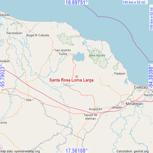
| Upper-left | 18.89751°, | -95.79023° |
| Center: | 18.23098°, | -95.0871° |
| Lower-right: | 17.56188°, | -94.38398° |
| Map W x H: | 148.5×148.5 km | = 92.3×92.3mi |
| max Lat: | 32.7° ⇑75.8% North |
| Santa Rosa Loma Larga: | 18.23098° |
| min Lat: | ⇓24.2% South 14.53588° |
| min Long | Santa Rosa Loma | max Long |
| -117.105° | -95.0871° | -86.73105° |
| W 84.3%⇐ | ⇒15.7% E |
Elevation
Elevation of Santa Rosa Loma Larga is 375 m = 1230 ft, and this is 878.7 m = 2883 ft below average elevation for this country.
| Max E: |
3497 m = 11473 ft | 70.9% |
| Avg. | 1253.7 m = 4113 ft | |
| Santa Rosa Loma Larga | 375 m = 1230 ft | |
Min E: |
-1 m = -3 ft | 29.1% |
See also: Mexico elevation on elevation.city.
Geographical zone
Santa Rosa Loma Larga is located in North Torrid zone (between Equator and Tropic of Cancer). Distance of this Northern Tropic circle is 578.8 km =359.6 mi to North.| Distance of | km | miles | from Santa Rosa Loma Larga |
|---|---|---|---|
| North Pole | 7980 | 4958.5 | to North |
| Arctic Circle | 5374.1 | 3339.3 | to North |
| Tropic Cancer | 578.8 | 359.6 | to North |
| Equator | 2027.1 | 1259.6 | to South |


Nearby cities:
15 places around Santa Rosa Loma Larga: (largest is in red/bold)
• Colonia Hermosa
12.4 km =7.7 mi,  160°
160°
• El Aguacate
12.8 km =8 mi,  106°
106°
• General Hilario C. Salas
11 km =6.8 mi,  65°
65°
• Hueyapan de Ocampo
11.6 km =7.2 mi,  214°
214°
• Juan Díaz Covarrubias
13.2 km =8.2 mi,  232°
232°
• La Candelaria
11.8 km =7.3 mi,  337°
337°
• Loma de Sogotegoyo
12 km =7.5 mi,  96°
96°
• Loma de la Palma
10.6 km =6.6 mi,  81°
81°
• Los Mangos
4 km =2.5 mi,  290°
290°
• Nacaxtle
9 km =5.6 mi, 159°
• Sabaneta
1.1 km =0.7 mi,  142°
142°
• San Juan Seco de Valencia
11.4 km =7.1 mi,  320°
320°
• Tierra Nueva
7.3 km =4.5 mi, 110°
• Zapoapan de Amapan
10.3 km =6.4 mi,  274°
274°
• Zapoapan de Cabañas
11.5 km =7.1 mi,  354°
354°
Sources, notices
• [Note1] Compared only with cities in Mexico existing in our database
• [Src1] Map data: © OpenStreetMap contributors (CC-BY-SA)
• [Src2] Other city data from geonames.org with taken over terms of usage.
• [Src3] Geographical zone / Annual Mean Temperature by Robert A. Rohde @ Wikipedia
