La Gloria geodata
La Gloria (Veracruz) is a populated place; located in Mexico in America/Mexico_City (GMT-6) time zone. With population of 820 people, there are 10646 cities with bigger population in this country. Compared to other cities in Mexico, 76.5% of cities are located further ↑North; 83.9% of cities are located further ←West and 86.7% of cities have higher elevation than La Gloria. Note1


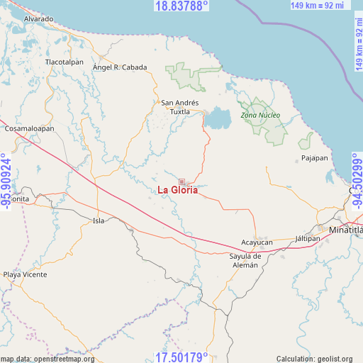
La Gloria GPS coordinates[2]
18° 10' 15.996" North, 95° 12' 21.996" West
| Map corner | latitude | longitude |
|---|---|---|
| Upper-left | 18.83788°, | -95.90924° |
| Center: | 18.17111°, | -95.20611° |
| Lower-right: | 17.50179°, | -94.50299° |
| Map W x H: | 148.6×148.6 km | = 92.3×92.3mi |
| max Lat: | 32.7° ⇑76.5% North |
| La Gloria: | 18.17111° |
| min Lat: | ⇓23.5% South 14.53588° |
| min Long | La Gloria | max Long |
| -117.105° | -95.20611° | -86.73105° |
| W 83.9%⇐ | ⇒16.1% E |
Elevation
Elevation of La Gloria is 35 m = 115 ft, and this is 1218.7 m = 3998 ft below average elevation for this country.
| Max E: |
3497 m = 11473 ft | 86.7% |
| Avg. | 1253.7 m = 4113 ft | |
| La Gloria | 35 m = 115 ft | |
Min E: |
-1 m = -3 ft | 13.3% |
See also: Mexico elevation on elevation.city.
Geographical zone
La Gloria is located in North Torrid zone (between Equator and Tropic of Cancer). Distance of this Northern Tropic circle is 585.5 km =363.8 mi to North.| Distance of | km | miles | from La Gloria |
|---|---|---|---|
| North Pole | 7986.6 | 4962.6 | to North |
| Arctic Circle | 5380.7 | 3343.4 | to North |
| Tropic Cancer | 585.5 | 363.8 | to North |
| Equator | 2020.4 | 1255.4 | to South |


Nearby cities:
15 places around La Gloria: (largest is in red/bold)
• Abrevadero
12.4 km =7.7 mi,  355°
355°
• Corral Nuevo
11.5 km =7.1 mi,  123°
123°
• Cuatotolapan Viejo
6.9 km =4.3 mi,  246°
246°
• Cuesta de Laja
13.7 km =8.5 mi,  353°
353°
• El Blanco
13.3 km =8.3 mi,  216°
216°
• El Popotal
13.3 km =8.3 mi,  308°
308°
• El Sauzal
2.2 km =1.4 mi, 307°
• Hueyapan de Ocampo
6.7 km =4.2 mi, 115°
• Juan Díaz Covarrubias
2.4 km =1.5 mi, 121°
• Loma de los Ingleses
4.7 km =2.9 mi,  135°
135°
• Los Mangos
12 km =7.5 mi,  47°
47°
• Norma
10.8 km =6.7 mi,  287°
287°
• San Ángel
10.8 km =6.7 mi,  125°
125°
• Santa Catalina
0.9 km =0.6 mi,  191°
191°
• Zapoapan de Amapan
7.8 km =4.8 mi,  17°
17°
Sources, notices
• [Note1] Compared only with cities in Mexico existing in our database
• [Src1] Map data: © OpenStreetMap contributors (CC-BY-SA)
• [Src2] Other city data from geonames.org with taken over terms of usage.
• [Src3] Geographical zone / Annual Mean Temperature by Robert A. Rohde @ Wikipedia
