Yutanduchi de Guerrero geodata
Yutanduchi de Guerrero (Oaxaca) is a populated place; located in Mexico in America/Mexico_City (GMT-6) time zone. With population of 1,148 people, there are 7555 cities with bigger population in this country. Compared to other cities in Mexico, 88.3% of cities are located further ↑North; 71.5% of cities are located further ←West and 56.2% of cities have lower elevation than Yutanduchi de Guerrero. Note1


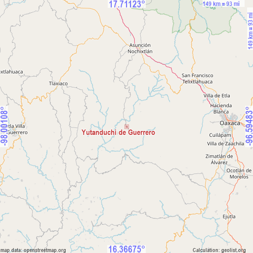
Yutanduchi de Guerrero GPS coordinates[2]
17° 2' 24.72" North, 97° 17' 52.62" West
| Map corner | latitude | longitude |
|---|---|---|
| Upper-left | 17.71123°, | -98.00108° |
| Center: | 17.0402°, | -97.29795° |
| Lower-right: | 16.36675°, | -96.59483° |
| Map W x H: | 149.5×149.5 km | = 92.9×92.9mi |
| max Lat: | 32.7° ⇑88.3% North |
| Yutanduchi de Guerrero: | 17.0402° |
| min Lat: | ⇓11.7% South 14.53588° |
| min Long | Yutanduchi de G | max Long |
| -117.105° | -97.29795° | -86.73105° |
| W 71.5%⇐ | ⇒28.5% E |
Elevation
Elevation of Yutanduchi de Guerrero is 1628 m = 5341 ft, and this is 374.3 m = 1228 ft above average elevation for this country.
| Max E: |
3497 m = 11473 ft | 43.8% |
| Yutanduchi de Guerrero | 1628 m 5341 ft | |
| Avg. | 1253.7 m = 4113 ft | |
Min E: |
-1 m = -3 ft | 56.2% |
See also: Mexico elevation on elevation.city.
Geographical zone
Yutanduchi de Guerrero is located in North Torrid zone (between Equator and Tropic of Cancer). Distance of this Northern Tropic circle is 711.2 km =441.9 mi to North.| Distance of | km | miles | from Yutanduchi de Guerrero |
|---|---|---|---|
| North Pole | 8112.4 | 5040.8 | to North |
| Arctic Circle | 5506.5 | 3421.6 | to North |
| Tropic Cancer | 711.2 | 441.9 | to North |
| Equator | 1894.7 | 1177.3 | to South |


Nearby cities:
15 places around Yutanduchi de Guerrero: (largest is in red/bold)
• Buenavista
22.6 km =14 mi,  288°
288°
• Llano de la Canoa
10.4 km =6.5 mi,  55°
55°
• Progreso
29 km =18 mi,  271°
271°
• San Antonio Huitepec
20.3 km =12.6 mi,  127°
127°
• San Francisco Cahuacuá
16 km =9.9 mi,  182°
182°
• San Juan Diuxi
28.4 km =17.6 mi,  344°
344°
• San Juan Teita
13.9 km =8.6 mi,  296°
296°
• San Mateo Peñasco
27.9 km =17.3 mi, 296°
• San Mateo Sindihui
6.9 km =4.3 mi,  234°
234°
• San Pedro el Alto
21.1 km =13.1 mi,  305°
305°
• Santa Catarina Ticuá
25.5 km =15.8 mi,  277°
277°
• Santa Cruz Tacahua
24.6 km =15.3 mi,  236°
236°
• Santiago Huaxolotipac
23.7 km =14.7 mi,  108°
108°
• Santiago Tilantongo
27.5 km =17.1 mi,  350°
350°
• Villa Chalcatongo de Hidalgo
29 km =18 mi, 268°
Sources, notices
• [Note1] Compared only with cities in Mexico existing in our database
• [Src1] Map data: © OpenStreetMap contributors (CC-BY-SA)
• [Src2] Other city data from geonames.org with taken over terms of usage.
• [Src3] Geographical zone / Annual Mean Temperature by Robert A. Rohde @ Wikipedia
