San Mateo Peñasco geodata
San Mateo Peñasco (Oaxaca) is a populated place; located in Mexico in America/Mexico_City (GMT-6) time zone. With population of 805 people, there are 10845 cities with bigger population in this country. Compared to other cities in Mexico, 87.1% of cities are located further ↑North; 69.2% of cities are located further ←West and 67.3% of cities have lower elevation than San Mateo Peñasco. Note1


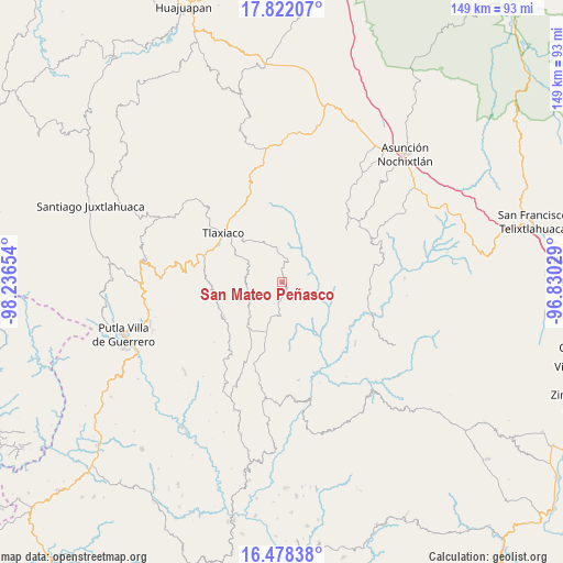
San Mateo Peñasco GPS coordinates[2]
17° 9' 5.184" North, 97° 32' 0.276" West
| Map corner | latitude | longitude |
|---|---|---|
| Upper-left | 17.82207°, | -98.23654° |
| Center: | 17.15144°, | -97.53341° |
| Lower-right: | 16.47838°, | -96.83029° |
| Map W x H: | 149.4×149.4 km | = 92.8×92.8mi |
| max Lat: | 32.7° ⇑87.1% North |
| San Mateo Peñasco: | 17.15144° |
| min Lat: | ⇓12.9% South 14.53588° |
| min Long | San Mateo Peña | max Long |
| -117.105° | -97.53341° | -86.73105° |
| W 69.2%⇐ | ⇒30.8% E |
Elevation
Elevation of San Mateo Peñasco is 1875 m = 6152 ft, and this is 621.3 m = 2038 ft above average elevation for this country.
| Max E: |
3497 m = 11473 ft | 32.7% |
| San Mateo Peñasco | 1875 m 6152 ft | |
| Avg. | 1253.7 m = 4113 ft | |
Min E: |
-1 m = -3 ft | 67.3% |
See also: Mexico elevation on elevation.city.
Geographical zone
San Mateo Peñasco is located in North Torrid zone (between Equator and Tropic of Cancer). Distance of this Northern Tropic circle is 698.9 km =434.3 mi to North.| Distance of | km | miles | from San Mateo Peñasco |
|---|---|---|---|
| North Pole | 8100 | 5033.1 | to North |
| Arctic Circle | 5494.1 | 3413.9 | to North |
| Tropic Cancer | 698.9 | 434.3 | to North |
| Equator | 1907.1 | 1185 | to South |


Nearby cities:
15 places around San Mateo Peñasco: (largest is in red/bold)
• Buenavista
6.3 km =3.9 mi,  144°
144°
• Ignacio Zaragoza
14.8 km =9.2 mi,  209°
209°
• Llano de Guadalupe
9.7 km =6 mi,  281°
281°
• Ojo de Agua
18.8 km =11.7 mi,  264°
264°
• Progreso
12.4 km =7.7 mi,  198°
198°
• San Cristóbal Amoltepec
15.3 km =9.5 mi,  344°
344°
• San Esteban Atatlahuca
18 km =11.2 mi,  238°
238°
• San Isidro
8.3 km =5.2 mi,  330°
330°
• San Juan Teita
14 km =8.7 mi,  115°
115°
• San Miguel Achiutla
18.3 km =11.4 mi,  16°
16°
• San Miguel el Grande Villa Juárez
14.9 km =9.3 mi,  218°
218°
• San Pedro el Alto
7.7 km =4.8 mi,  91°
91°
• Santa Catarina Ticuá
8.8 km =5.5 mi,  181°
181°
• Villa Chalcatongo de Hidalgo
13.8 km =8.6 mi, 196°
• Villa de Guadalupe Victoria
12.2 km =7.6 mi, 222°
Sources, notices
• [Note1] Compared only with cities in Mexico existing in our database
• [Src1] Map data: © OpenStreetMap contributors (CC-BY-SA)
• [Src2] Other city data from geonames.org with taken over terms of usage.
• [Src3] Geographical zone / Annual Mean Temperature by Robert A. Rohde @ Wikipedia
