Xuchapa geodata
Xuchapa (Puebla) is a populated place; located in Mexico in America/Mexico_City (GMT-6) time zone. With population of 1,278 people, there are 6782 cities with bigger population in this country. Compared to other cities in Mexico, 72.3% of cities are located further ↑North; 57.8% of cities are located further ←West and 53.4% of cities have higher elevation than Xuchapa. Note1


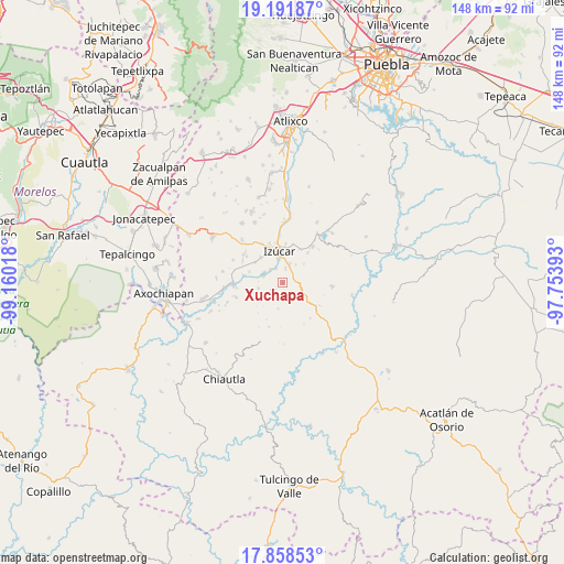
Xuchapa GPS coordinates[2]
18° 31' 35.4" North, 98° 27' 25.38" West
| Map corner | latitude | longitude |
|---|---|---|
| Upper-left | 19.19187°, | -99.16018° |
| Center: | 18.5265°, | -98.45705° |
| Lower-right: | 17.85853°, | -97.75393° |
| Map W x H: | 148.3×148.3 km | = 92.1×92.1mi |
| max Lat: | 32.7° ⇑72.3% North |
| Xuchapa: | 18.5265° |
| min Lat: | ⇓27.7% South 14.53588° |
| min Long | Xuchapa | max Long |
| -117.105° | -98.45705° | -86.73105° |
| W 57.8%⇐ | ⇒42.2% E |
Elevation
Elevation of Xuchapa is 1273 m = 4177 ft, and this is 19.3 m = 63 ft above average elevation for this country.
| Max E: |
3497 m = 11473 ft | 53.4% |
| Xuchapa | 1273 m 4177 ft | |
| Avg. | 1253.7 m = 4113 ft | |
Min E: |
-1 m = -3 ft | 46.6% |
See also: Mexico elevation on elevation.city.
Geographical zone
Xuchapa is located in North Torrid zone (between Equator and Tropic of Cancer). Distance of this Northern Tropic circle is 546 km =339.3 mi to North.| Distance of | km | miles | from Xuchapa |
|---|---|---|---|
| North Pole | 7947.1 | 4938.1 | to North |
| Arctic Circle | 5341.2 | 3318.9 | to North |
| Tropic Cancer | 546 | 339.3 | to North |
| Equator | 2060 | 1280 | to South |


Nearby cities:
15 places around Xuchapa: (largest is in red/bold)
• Agua Escondida (Santa Cruz Agua Escondida)
3.8 km =2.4 mi,  9°
9°
• Atzala
10.4 km =6.5 mi,  282°
282°
• Ayutla
5.5 km =3.4 mi,  292°
292°
• Casa Blanca (Cuyotliapa)
8.8 km =5.5 mi,  318°
318°
• Colucan
3.2 km =2 mi,  232°
232°
• Izúcar de Matamoros
8.4 km =5.2 mi,  356°
356°
• Matzaco
4.9 km =3 mi, 318°
• Puctla
4.2 km =2.6 mi,  332°
332°
• Pueblo Nuevo de Porfirio Díaz
10.5 km =6.5 mi,  261°
261°
• San Carlos
6.6 km =4.1 mi, 257°
• San José las Bocas
9.8 km =6.1 mi,  25°
25°
• San Juan Raboso
5.3 km =3.3 mi,  20°
20°
• San Nicolás Tolentino
5.6 km =3.5 mi,  298°
298°
• San Pedro Calantla
10.1 km =6.3 mi,  39°
39°
• Zolonquiapa
9.2 km =5.7 mi,  306°
306°
Sources, notices
• [Note1] Compared only with cities in Mexico existing in our database
• [Src1] Map data: © OpenStreetMap contributors (CC-BY-SA)
• [Src2] Other city data from geonames.org with taken over terms of usage.
• [Src3] Geographical zone / Annual Mean Temperature by Robert A. Rohde @ Wikipedia
