Izúcar de Matamoros geodata
Izúcar de Matamoros (Puebla) is a seat of a second-order administrative division; located in Mexico in America/Mexico_City (GMT-6) time zone. With population of 42,936 people, there are 248 cities with bigger population in this country. Compared to other cities in Mexico, 71.4% of cities are located further ↑North; 57.7% of cities are located further ←West and 52.9% of cities have higher elevation than Izúcar de Matamoros. Note1


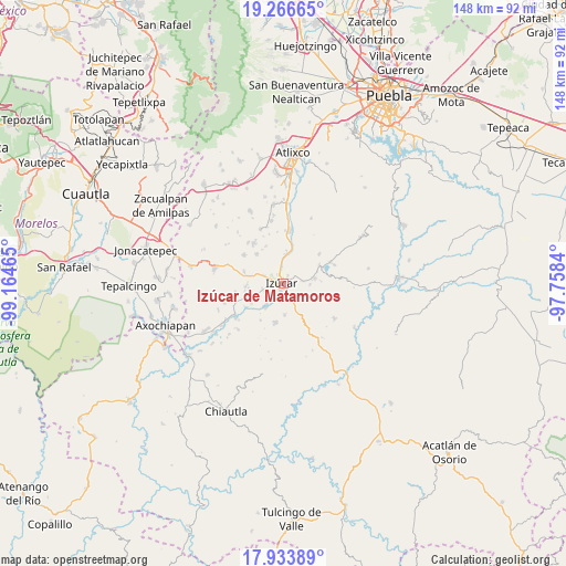
Izúcar de Matamoros GPS coordinates[2]
18° 36' 5.652" North, 98° 27' 41.472" West
| Map corner | latitude | longitude |
|---|---|---|
| Upper-left | 19.26665°, | -99.16465° |
| Center: | 18.60157°, | -98.46152° |
| Lower-right: | 17.93389°, | -97.7584° |
| Map W x H: | 148.2×148.2 km | = 92.1×92.1mi |
| max Lat: | 32.7° ⇑71.4% North |
| Izúcar de Matamoros: | 18.60157° |
| min Lat: | ⇓28.6% South 14.53588° |
| min Long | Izúcar de Mata | max Long |
| -117.105° | -98.46152° | -86.73105° |
| W 57.7%⇐ | ⇒42.3% E |
Elevation
Elevation of Izúcar de Matamoros is 1292 m = 4239 ft, and this is 38.3 m = 126 ft above average elevation for this country.
| Max E: |
3497 m = 11473 ft | 52.9% |
| Izúcar de Matamoros | 1292 m 4239 ft | |
| Avg. | 1253.7 m = 4113 ft | |
Min E: |
-1 m = -3 ft | 47.1% |
See also: Izúcar de Matamoros elevation on elevation.city.
Geographical zone
Izúcar de Matamoros is located in North Torrid zone (between Equator and Tropic of Cancer). Distance of this Northern Tropic circle is 537.6 km =334 mi to North.| Distance of | km | miles | from Izúcar de Matamoros |
|---|---|---|---|
| North Pole | 7938.8 | 4932.9 | to North |
| Arctic Circle | 5332.9 | 3313.7 | to North |
| Tropic Cancer | 537.6 | 334 | to North |
| Equator | 2068.3 | 1285.2 | to South |


Nearby cities:
15 places around Izúcar de Matamoros: (largest is in red/bold)
• Agua Dulce
5.6 km =3.5 mi,  290°
290°
• Agua Escondida (Santa Cruz Agua Escondida)
4.7 km =2.9 mi,  166°
166°
• Ayutla
7.8 km =4.8 mi,  216°
216°
• Casa Blanca (Cuyotliapa)
5.7 km =3.5 mi,  251°
251°
• La Galarza
7.4 km =4.6 mi,  5°
5°
• Matzaco
5.5 km =3.4 mi,  211°
211°
• Puctla
4.9 km =3 mi,  197°
197°
• San José las Bocas
4.8 km =3 mi,  83°
83°
• San Juan Raboso
4.1 km =2.5 mi,  145°
145°
• San Nicolás Tolentino
7.2 km =4.5 mi, 218°
• San Pedro Calantla
7 km =4.3 mi,  94°
94°
• Santa Ana Necoxtla
8.4 km =5.2 mi, 81°
• Tilapa
9.5 km =5.9 mi,  267°
267°
• Xuchapa
8.4 km =5.2 mi,  176°
176°
• Zolonquiapa
7.5 km =4.7 mi, 247°
Sources, notices
• [Note1] Compared only with cities in Mexico existing in our database
• [Src1] Map data: © OpenStreetMap contributors (CC-BY-SA)
• [Src2] Other city data from geonames.org with taken over terms of usage.
• [Src3] Geographical zone / Annual Mean Temperature by Robert A. Rohde @ Wikipedia
