San Juan Raboso geodata
San Juan Raboso (Puebla) is a populated place; located in Mexico in America/Mexico_City (GMT-6) time zone. With population of 3,637 people, there are 2521 cities with bigger population in this country. Compared to other cities in Mexico, 71.8% of cities are located further ↑North; 58.1% of cities are located further ←West and 53.4% of cities have higher elevation than San Juan Raboso. Note1


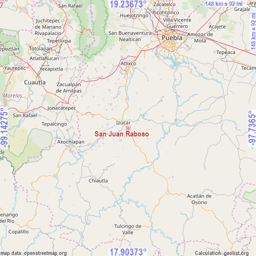
San Juan Raboso GPS coordinates[2]
18° 34' 17.508" North, 98° 26' 22.632" West
| Map corner | latitude | longitude |
|---|---|---|
| Upper-left | 19.23673°, | -99.14275° |
| Center: | 18.57153°, | -98.43962° |
| Lower-right: | 17.90373°, | -97.7365° |
| Map W x H: | 148.2×148.2 km | = 92.1×92.1mi |
| max Lat: | 32.7° ⇑71.8% North |
| San Juan Raboso: | 18.57153° |
| min Lat: | ⇓28.2% South 14.53588° |
| min Long | San Juan Raboso | max Long |
| -117.105° | -98.43962° | -86.73105° |
| W 58.1%⇐ | ⇒41.9% E |
Elevation
Elevation of San Juan Raboso is 1272 m = 4173 ft, and this is 18.3 m = 60 ft above average elevation for this country.
| Max E: |
3497 m = 11473 ft | 53.4% |
| San Juan Raboso | 1272 m 4173 ft | |
| Avg. | 1253.7 m = 4113 ft | |
Min E: |
-1 m = -3 ft | 46.6% |
See also: Mexico elevation on elevation.city.
Geographical zone
San Juan Raboso is located in North Torrid zone (between Equator and Tropic of Cancer). Distance of this Northern Tropic circle is 541 km =336.2 mi to North.| Distance of | km | miles | from San Juan Raboso |
|---|---|---|---|
| North Pole | 7942.1 | 4935 | to North |
| Arctic Circle | 5336.2 | 3315.8 | to North |
| Tropic Cancer | 541 | 336.2 | to North |
| Equator | 2065 | 1283.1 | to South |


Nearby cities:
15 places around San Juan Raboso: (largest is in red/bold)
• Agua Dulce
9.2 km =5.7 mi,  305°
305°
• Agua Escondida (Santa Cruz Agua Escondida)
1.7 km =1.1 mi,  223°
223°
• Ayutla
7.5 km =4.7 mi,  246°
246°
• Casa Blanca (Cuyotliapa)
7.9 km =4.9 mi,  281°
281°
• Colucan
8.2 km =5.1 mi,  211°
211°
• Izúcar de Matamoros
4.1 km =2.5 mi,  325°
325°
• Matzaco
5.3 km =3.3 mi,  255°
255°
• Puctla
4 km =2.5 mi, 251°
• San Carlos
10.5 km =6.5 mi,  231°
231°
• San José las Bocas
4.6 km =2.9 mi,  32°
32°
• San Nicolás Tolentino
7.1 km =4.4 mi, 251°
• San Pedro Calantla
5.4 km =3.4 mi,  59°
59°
• Santa Ana Necoxtla
7.5 km =4.7 mi,  52°
52°
• Xuchapa
5.3 km =3.3 mi,  200°
200°
• Zolonquiapa
9.2 km =5.7 mi,  273°
273°
Sources, notices
• [Note1] Compared only with cities in Mexico existing in our database
• [Src1] Map data: © OpenStreetMap contributors (CC-BY-SA)
• [Src2] Other city data from geonames.org with taken over terms of usage.
• [Src3] Geographical zone / Annual Mean Temperature by Robert A. Rohde @ Wikipedia
