Xocchel geodata
Xocchel (Yucatán) is a populated place; located in Mexico in America/Merida (GMT-6) time zone. With population of 3,229 people, there are 2805 cities with bigger population in this country. Compared to other cities in Mexico, 73.8% of cities are located further ↓South; 98.6% of cities are located further ←West and 94% of cities have higher elevation than Xocchel. Note1


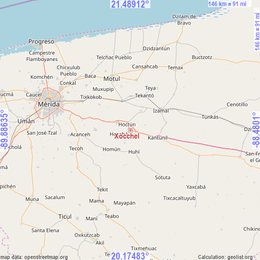
Xocchel GPS coordinates[2]
20° 50' 0.276" North, 89° 10' 59.592" West
| Map corner | latitude | longitude |
|---|---|---|
| Upper-left | 21.48912°, | -89.88635° |
| Center: | 20.83341°, | -89.18322° |
| Lower-right: | 20.17483°, | -88.4801° |
| Map W x H: | 146.1×146.1 km | = 90.8×90.8mi |
| max Lat: | 32.7° ⇑26.2% North |
| Xocchel: | 20.83341° |
| min Lat: | ⇓73.8% South 14.53588° |
| min Long | Xocchel | max Long |
| -117.105° | -89.18322° | -86.73105° |
| W 98.6%⇐ | ⇒1.4% E |
Elevation
Elevation of Xocchel is 15 m = 49 ft, and this is 1238.7 m = 4064 ft below average elevation for this country.
| Max E: |
3497 m = 11473 ft | 94% |
| Avg. | 1253.7 m = 4113 ft | |
| Xocchel | 15 m = 49 ft | |
Min E: |
-1 m = -3 ft | 6% |
See also: Mexico elevation on elevation.city.
Geographical zone
Xocchel is located in North Torrid zone (between Equator and Tropic of Cancer). Distance of this Northern Tropic circle is 289.5 km =179.9 mi to North.| Distance of | km | miles | from Xocchel |
|---|---|---|---|
| North Pole | 7690.6 | 4778.7 | to North |
| Arctic Circle | 5084.7 | 3159.5 | to North |
| Tropic Cancer | 289.5 | 179.9 | to North |
| Equator | 2316.5 | 1439.4 | to South |


Nearby cities:
15 places around Xocchel: (largest is in red/bold)
• Cacalchen
17.3 km =10.7 mi,  344°
344°
• Citilcum
14.8 km =9.2 mi,  27°
27°
• Cuzama
17.3 km =10.7 mi,  233°
233°
• Hocaba
6.8 km =4.2 mi,  253°
253°
• Hoctun
4 km =2.5 mi,  332°
332°
• Holactun
15.9 km =9.9 mi,  287°
287°
• Homun
14.9 km =9.3 mi, 225°
• Huhi
12.2 km =7.6 mi,  168°
168°
• Kantunil
15.9 km =9.9 mi,  104°
104°
• Kimbila
12.7 km =7.9 mi, 28°
• Sahcaba
4.6 km =2.9 mi,  177°
177°
• San José Oriente
8.9 km =5.5 mi,  70°
70°
• Sanahcat
7.6 km =4.7 mi,  205°
205°
• Tahmek
8.7 km =5.4 mi,  301°
301°
• Xanabá
17.6 km =10.9 mi,  89°
89°
Sources, notices
• [Note1] Compared only with cities in Mexico existing in our database
• [Src1] Map data: © OpenStreetMap contributors (CC-BY-SA)
• [Src2] Other city data from geonames.org with taken over terms of usage.
• [Src3] Geographical zone / Annual Mean Temperature by Robert A. Rohde @ Wikipedia
