Hocaba geodata
Hocaba (Yucatán) is a populated place; located in Mexico in America/Merida (GMT-6) time zone. With population of 4,127 people, there are 2217 cities with bigger population in this country. Compared to other cities in Mexico, 73.5% of cities are located further ↓South; 98.5% of cities are located further ←West and 91.2% of cities have higher elevation than Hocaba. Note1


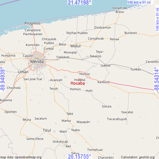
Hocaba GPS coordinates[2]
20° 48' 58.32" North, 89° 14' 46.536" West
| Map corner | latitude | longitude |
|---|---|---|
| Upper-left | 21.47198°, | -89.94939° |
| Center: | 20.8162°, | -89.24626° |
| Lower-right: | 20.15755°, | -88.54314° |
| Map W x H: | 146.2×146.2 km | = 90.8×90.8mi |
| max Lat: | 32.7° ⇑26.5% North |
| Hocaba: | 20.8162° |
| min Lat: | ⇓73.5% South 14.53588° |
| min Long | Hocaba | max Long |
| -117.105° | -89.24626° | -86.73105° |
| W 98.5%⇐ | ⇒1.5% E |
Elevation
Elevation of Hocaba is 21 m = 69 ft, and this is 1232.7 m = 4044 ft below average elevation for this country.
| Max E: |
3497 m = 11473 ft | 91.2% |
| Avg. | 1253.7 m = 4113 ft | |
| Hocaba | 21 m = 69 ft | |
Min E: |
-1 m = -3 ft | 8.8% |
See also: Mexico elevation on elevation.city.
Geographical zone
Hocaba is located in North Torrid zone (between Equator and Tropic of Cancer). Distance of this Northern Tropic circle is 291.4 km =181.1 mi to North.| Distance of | km | miles | from Hocaba |
|---|---|---|---|
| North Pole | 7692.5 | 4779.9 | to North |
| Arctic Circle | 5086.6 | 3160.7 | to North |
| Tropic Cancer | 291.4 | 181.1 | to North |
| Equator | 2314.5 | 1438.2 | to South |


Nearby cities:
15 places around Hocaba: (largest is in red/bold)
• Cacalchen
18.7 km =11.6 mi,  6°
6°
• Cuzama
11.1 km =6.9 mi,  221°
221°
• Ekmul
19.7 km =12.2 mi,  326°
326°
• Eknakan
14.4 km =8.9 mi,  242°
242°
• Hoctun
7.2 km =4.5 mi,  40°
40°
• Holactun
10.9 km =6.8 mi,  308°
308°
• Homun
9.5 km =5.9 mi,  205°
205°
• Huhi
13.4 km =8.3 mi,  138°
138°
• Kimbila
18.2 km =11.3 mi, 43°
• Sahcaba
7.3 km =4.5 mi,  111°
111°
• San José Oriente
15.7 km =9.8 mi,  71°
71°
• Sanahcat
6 km =3.7 mi,  145°
145°
• Seyé
13.2 km =8.2 mi,  279°
279°
• Tahmek
6.4 km =4 mi,  352°
352°
• Xocchel
6.8 km =4.2 mi, 73°
Sources, notices
• [Note1] Compared only with cities in Mexico existing in our database
• [Src1] Map data: © OpenStreetMap contributors (CC-BY-SA)
• [Src2] Other city data from geonames.org with taken over terms of usage.
• [Src3] Geographical zone / Annual Mean Temperature by Robert A. Rohde @ Wikipedia
