Tahmek geodata
Tahmek (Yucatán) is a populated place; located in Mexico in America/Merida (GMT-6) time zone. With population of 3,493 people, there are 2615 cities with bigger population in this country. Compared to other cities in Mexico, 74.4% of cities are located further ↓South; 98.5% of cities are located further ←West and 94% of cities have higher elevation than Tahmek. Note1


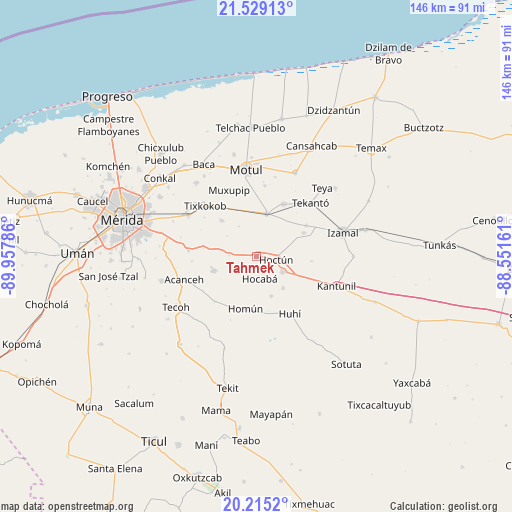
Tahmek GPS coordinates[2]
20° 52' 24.96" North, 89° 15' 17.028" West
| Map corner | latitude | longitude |
|---|---|---|
| Upper-left | 21.52913°, | -89.95786° |
| Center: | 20.8736°, | -89.25473° |
| Lower-right: | 20.2152°, | -88.55161° |
| Map W x H: | 146.1×146.1 km | = 90.8×90.8mi |
| max Lat: | 32.7° ⇑25.6% North |
| Tahmek: | 20.8736° |
| min Lat: | ⇓74.4% South 14.53588° |
| min Long | Tahmek | max Long |
| -117.105° | -89.25473° | -86.73105° |
| W 98.5%⇐ | ⇒1.5% E |
Elevation
Elevation of Tahmek is 15 m = 49 ft, and this is 1238.7 m = 4064 ft below average elevation for this country.
| Max E: |
3497 m = 11473 ft | 94% |
| Avg. | 1253.7 m = 4113 ft | |
| Tahmek | 15 m = 49 ft | |
Min E: |
-1 m = -3 ft | 6% |
See also: Mexico elevation on elevation.city.
Geographical zone
Tahmek is located in North Torrid zone (between Equator and Tropic of Cancer). Distance of this Northern Tropic circle is 285 km =177.1 mi to North.| Distance of | km | miles | from Tahmek |
|---|---|---|---|
| North Pole | 7686.1 | 4775.9 | to North |
| Arctic Circle | 5080.2 | 3156.7 | to North |
| Tropic Cancer | 285 | 177.1 | to North |
| Equator | 2320.9 | 1442.1 | to South |


Nearby cities:
15 places around Tahmek: (largest is in red/bold)
• Cacalchen
12.6 km =7.8 mi,  13°
13°
• Cholul Cantón
15.7 km =9.8 mi,  345°
345°
• Cuzama
16 km =9.9 mi,  203°
203°
• Ekmul
14.2 km =8.8 mi,  315°
315°
• Euan
16.4 km =10.2 mi,  326°
326°
• Hocaba
6.4 km =4 mi,  172°
172°
• Hoctun
5.6 km =3.5 mi,  99°
99°
• Holactun
7.7 km =4.8 mi,  272°
272°
• Homun
15.3 km =9.5 mi,  191°
191°
• Kimbila
15.1 km =9.4 mi,  63°
63°
• Sahcaba
11.9 km =7.4 mi,  140°
140°
• San José Oriente
15.9 km =9.9 mi, 95°
• Sanahcat
12.1 km =7.5 mi,  159°
159°
• Seyé
12.9 km =8 mi,  250°
250°
• Xocchel
8.7 km =5.4 mi,  121°
121°
Sources, notices
• [Note1] Compared only with cities in Mexico existing in our database
• [Src1] Map data: © OpenStreetMap contributors (CC-BY-SA)
• [Src2] Other city data from geonames.org with taken over terms of usage.
• [Src3] Geographical zone / Annual Mean Temperature by Robert A. Rohde @ Wikipedia
