Villahermosa geodata
Villahermosa (Tabasco) is a seat of a first-order administrative division; located in Mexico in America/Mexico_City (GMT-6) time zone. With population of 353,577 people, there are 57 cities with bigger population in this country. Compared to other cities in Mexico, 78.8% of cities are located further ↑North; 89% of cities are located further ←West and 90.4% of cities have higher elevation than Villahermosa. Note1


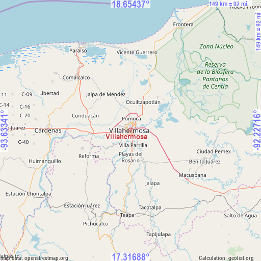
Villahermosa GPS coordinates[2]
17° 59' 12.804" North, 92° 55' 49.008" West
| Map corner | latitude | longitude |
|---|---|---|
| Upper-left | 18.65437°, | -93.63341° |
| Center: | 17.98689°, | -92.93028° |
| Lower-right: | 17.31688°, | -92.22716° |
| Map W x H: | 148.7×148.7 km | = 92.4×92.4mi |
| max Lat: | 32.7° ⇑78.8% North |
| Villahermosa: | 17.98689° |
| min Lat: | ⇓21.2% South 14.53588° |
| min Long | Villahermosa | max Long |
| -117.105° | -92.93028° | -86.73105° |
| W 89%⇐ | ⇒11% E |
Elevation
Elevation of Villahermosa is 23 m = 75 ft, and this is 1230.7 m = 4038 ft below average elevation for this country.
| Max E: |
3497 m = 11473 ft | 90.4% |
| Avg. | 1253.7 m = 4113 ft | |
| Villahermosa | 23 m = 75 ft | |
Min E: |
-1 m = -3 ft | 9.6% |
See also: Villahermosa elevation on elevation.city.
Geographical zone
Villahermosa is located in North Torrid zone (between Equator and Tropic of Cancer). Distance of this Northern Tropic circle is 606 km =376.6 mi to North.| Distance of | km | miles | from Villahermosa |
|---|---|---|---|
| North Pole | 8007.1 | 4975.4 | to North |
| Arctic Circle | 5401.2 | 3356.1 | to North |
| Tropic Cancer | 606 | 376.6 | to North |
| Equator | 2000 | 1242.7 | to South |


Nearby cities:
15 places around Villahermosa: (largest is in red/bold)
• Anacleto Canabal 3ra. Sección
7.2 km =4.5 mi,  298°
298°
• Aparceros
4.8 km =3 mi,  305°
305°
• Bosque de Saloya
4.4 km =2.7 mi,  317°
317°
• Brisas del Carrizal
5.3 km =3.3 mi, 306°
• El Cedro
4.8 km =3 mi,  337°
337°
• Emiliano Zapata
3.3 km =2.1 mi,  286°
286°
• Gaviotas Sur (El Cedral)
5.6 km =3.5 mi,  131°
131°
• La Manga 2da. Sección (El Jobal)
7.4 km =4.6 mi,  60°
60°
• La Selva
5.3 km =3.3 mi, 319°
• Los Sauces
5.4 km =3.4 mi,  15°
15°
• Manuel Buendía Téllez Girón
6 km =3.7 mi, 312°
• Medellín y Pigua 1ra. Sección
5.1 km =3.2 mi, 21°
• Plutarco Elías Calles (Cura Hueso)
2.6 km =1.6 mi,  156°
156°
• Pomoca
7 km =4.3 mi,  359°
359°
• Samarkanda
6.5 km =4 mi, 18°
In other languages:
- In Spanish: Villahermosa, Villa Hermosa
- In Russian: Вильяэрмоса
- In Chinese: 比亚埃尔莫萨
Sources, notices
• [Note1] Compared only with cities in Mexico existing in our database
• [Src1] Map data: © OpenStreetMap contributors (CC-BY-SA)
• [Src2] Other city data from geonames.org with taken over terms of usage.
• [Src3] Geographical zone / Annual Mean Temperature by Robert A. Rohde @ Wikipedia
