Pomoca geodata
Pomoca (Tabasco) is a populated place; located in Mexico in America/Mexico_City (GMT-6) time zone. With population of 10,864 people, there are 876 cities with bigger population in this country. Compared to other cities in Mexico, 78.1% of cities are located further ↑North; 89% of cities are located further ←West and 97% of cities have higher elevation than Pomoca. Note1


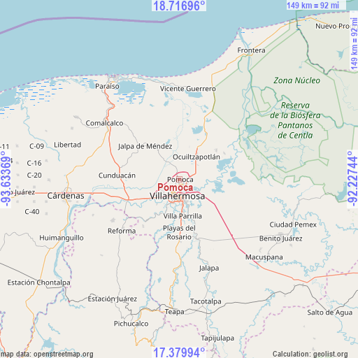
Pomoca GPS coordinates[2]
18° 2' 58.992" North, 92° 55' 50.016" West
| Map corner | latitude | longitude |
|---|---|---|
| Upper-left | 18.71696°, | -93.63369° |
| Center: | 18.04972°, | -92.93056° |
| Lower-right: | 17.37994°, | -92.22744° |
| Map W x H: | 148.7×148.7 km | = 92.4×92.4mi |
| max Lat: | 32.7° ⇑78.1% North |
| Pomoca: | 18.04972° |
| min Lat: | ⇓21.9% South 14.53588° |
| min Long | Pomoca | max Long |
| -117.105° | -92.93056° | -86.73105° |
| W 89%⇐ | ⇒11% E |
Elevation
Elevation of Pomoca is 10 m = 33 ft, and this is 1243.7 m = 4080 ft below average elevation for this country.
| Max E: |
3497 m = 11473 ft | 97% |
| Avg. | 1253.7 m = 4113 ft | |
| Pomoca | 10 m = 33 ft | |
Min E: |
-1 m = -3 ft | 3% |
See also: Mexico elevation on elevation.city.
Geographical zone
Pomoca is located in North Torrid zone (between Equator and Tropic of Cancer). Distance of this Northern Tropic circle is 599 km =372.2 mi to North.| Distance of | km | miles | from Pomoca |
|---|---|---|---|
| North Pole | 8000.1 | 4971 | to North |
| Arctic Circle | 5394.2 | 3351.8 | to North |
| Tropic Cancer | 599 | 372.2 | to North |
| Equator | 2006.9 | 1247 | to South |


Nearby cities:
15 places around Pomoca: (largest is in red/bold)
• Aparceros
5.7 km =3.5 mi,  222°
222°
• Bosque de Saloya
4.7 km =2.9 mi, 217°
• Brisas del Carrizal
5.7 km =3.5 mi,  228°
228°
• Constitución
6.7 km =4.2 mi,  67°
67°
• El Cedro
3.1 km =1.9 mi, 215°
• El Tigre
5.9 km =3.7 mi,  348°
348°
• La Selva
4.5 km =2.8 mi, 229°
• Lagartera 1ra. Sección
5 km =3.1 mi, 73°
• Lomitas
3.7 km =2.3 mi,  296°
296°
• Los Sauces
2.3 km =1.4 mi,  141°
141°
• Manuel Buendía Téllez Girón
5.3 km =3.3 mi,  236°
236°
• Medellín y Pigua 1ra. Sección
3 km =1.9 mi, 140°
• Saloya 2da. Sección
0.7 km =0.4 mi, 301°
• Samarkanda
2.3 km =1.4 mi,  111°
111°
• Tierra Amarilla 3ra. Sección
3.9 km =2.4 mi,  62°
62°
Sources, notices
• [Note1] Compared only with cities in Mexico existing in our database
• [Src1] Map data: © OpenStreetMap contributors (CC-BY-SA)
• [Src2] Other city data from geonames.org with taken over terms of usage.
• [Src3] Geographical zone / Annual Mean Temperature by Robert A. Rohde @ Wikipedia
