El Cedro geodata
El Cedro (Tabasco) is a populated place; located in Mexico in America/Mexico_City (GMT-6) time zone. With population of 3,805 people, there are 2401 cities with bigger population in this country. Compared to other cities in Mexico, 78.4% of cities are located further ↑North; 88.9% of cities are located further ←West and 97.5% of cities have higher elevation than El Cedro. Note1


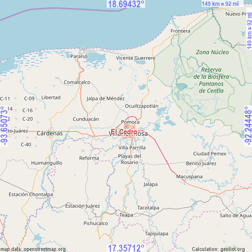
El Cedro GPS coordinates[2]
18° 1' 37.164" North, 92° 56' 51.36" West
| Map corner | latitude | longitude |
|---|---|---|
| Upper-left | 18.69432°, | -93.65073° |
| Center: | 18.02699°, | -92.9476° |
| Lower-right: | 17.35712°, | -92.24448° |
| Map W x H: | 148.7×148.7 km | = 92.4×92.4mi |
| max Lat: | 32.7° ⇑78.4% North |
| El Cedro: | 18.02699° |
| min Lat: | ⇓21.6% South 14.53588° |
| min Long | El Cedro | max Long |
| -117.105° | -92.9476° | -86.73105° |
| W 88.9%⇐ | ⇒11.1% E |
Elevation
Elevation of El Cedro is 9 m = 30 ft, and this is 1244.7 m = 4084 ft below average elevation for this country.
| Max E: |
3497 m = 11473 ft | 97.5% |
| Avg. | 1253.7 m = 4113 ft | |
| El Cedro | 9 m = 30 ft | |
Min E: |
-1 m = -3 ft | 2.5% |
See also: Mexico elevation on elevation.city.
Geographical zone
El Cedro is located in North Torrid zone (between Equator and Tropic of Cancer). Distance of this Northern Tropic circle is 601.5 km =373.8 mi to North.| Distance of | km | miles | from El Cedro |
|---|---|---|---|
| North Pole | 8002.6 | 4972.6 | to North |
| Arctic Circle | 5396.8 | 3353.4 | to North |
| Tropic Cancer | 601.5 | 373.8 | to North |
| Equator | 2004.4 | 1245.5 | to South |


Nearby cities:
15 places around El Cedro: (largest is in red/bold)
• Anacleto Canabal 3ra. Sección
4.6 km =2.9 mi,  257°
257°
• Aparceros
2.7 km =1.7 mi,  231°
231°
• Bosque de Saloya
1.6 km =1 mi,  222°
222°
• Brisas del Carrizal
2.8 km =1.7 mi,  242°
242°
• Emiliano Zapata
3.8 km =2.4 mi,  200°
200°
• La Selva
1.7 km =1.1 mi, 256°
• Lomitas
4.4 km =2.7 mi,  339°
339°
• Los Sauces
3.3 km =2.1 mi,  77°
77°
• Manuel Buendía Téllez Girón
2.6 km =1.6 mi, 261°
• Medellín y Pigua 1ra. Sección
3.7 km =2.3 mi,  86°
86°
• Pomoca
3.1 km =1.9 mi,  35°
35°
• Saloya 2da. Sección
3.1 km =1.9 mi,  22°
22°
• Samarkanda
4.3 km =2.7 mi,  66°
66°
• Tierra Amarilla 3ra. Sección
6.8 km =4.2 mi,  50°
50°
• Villahermosa
4.8 km =3 mi,  157°
157°
Sources, notices
• [Note1] Compared only with cities in Mexico existing in our database
• [Src1] Map data: © OpenStreetMap contributors (CC-BY-SA)
• [Src2] Other city data from geonames.org with taken over terms of usage.
• [Src3] Geographical zone / Annual Mean Temperature by Robert A. Rohde @ Wikipedia
