Manuel Buendía Téllez Girón geodata
Manuel Buendía Téllez Girón (Tabasco) is a populated place; located in Mexico in America/Mexico_City (GMT-6) time zone. With population of 700 people, there are 12436 cities with bigger population in this country. Compared to other cities in Mexico, 78.4% of cities are located further ↑North; 88.7% of cities are located further ←West and 98.7% of cities have higher elevation than Manuel Buendía Téllez Girón. Note1
Current local time in Manuel Buendía Téllez Girón:
05:37 AM, WednesdayDifference from your time zone: hours


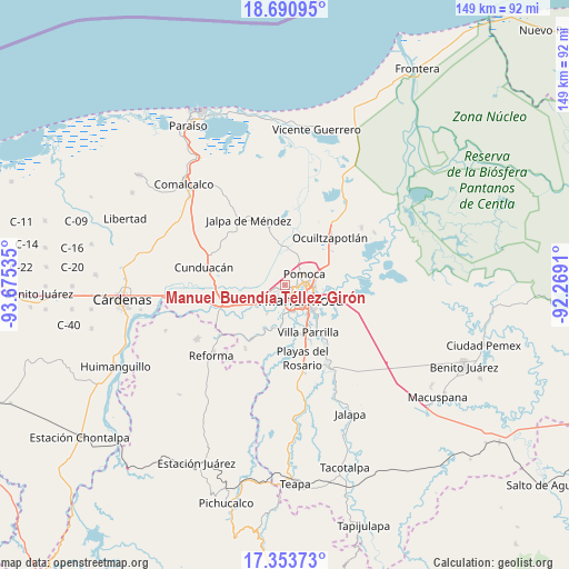
Manuel Buendía Téllez Girón GPS coordinates[2]
18° 1' 24.996" North, 92° 58' 19.992" West
| Map corner | latitude | longitude |
|---|---|---|
| Upper-left | 18.69095°, | -93.67535° |
| Center: | 18.02361°, | -92.97222° |
| Lower-right: | 17.35373°, | -92.2691° |
| Map W x H: | 148.7×148.7 km | = 92.4×92.4mi |
| max Lat: | 32.7° ⇑78.4% North |
| Manuel Buendía Téllez Girón: | 18.02361° |
| min Lat: | ⇓21.6% South 14.53588° |
| min Long | Manuel Buendía | max Long |
| -117.105° | -92.97222° | -86.73105° |
| W 88.7%⇐ | ⇒11.3% E |
Elevation
Elevation of Manuel Buendía Téllez Girón is 7 m = 23 ft, and this is 1246.7 m = 4090 ft below average elevation for this country.
| Max E: |
3497 m = 11473 ft | 98.7% |
| Avg. | 1253.7 m = 4113 ft | |
| Manuel Buendía Téllez Girón | 7 m = 23 ft | |
Min E: |
-1 m = -3 ft | 1.3% |
See also: Mexico elevation on elevation.city.
Geographical zone
Manuel Buendía Téllez Girón is located in North Torrid zone (between Equator and Tropic of Cancer). Distance of this Northern Tropic circle is 601.9 km =374 mi to North.| Distance of | km | miles | from Manuel Buendía Téllez Girón |
|---|---|---|---|
| North Pole | 8003 | 4972.8 | to North |
| Arctic Circle | 5397.1 | 3353.6 | to North |
| Tropic Cancer | 601.9 | 374 | to North |
| Equator | 2004 | 1245.2 | to South |


Nearby cities:
15 places around Manuel Buendía Téllez Girón: (largest is in red/bold)
• Anacleto Canabal 3ra. Sección
2 km =1.2 mi,  252°
252°
• Aparceros
1.4 km =0.9 mi,  159°
159°
• Bosque de Saloya
1.7 km =1.1 mi,  119°
119°
• Brisas del Carrizal
0.9 km =0.6 mi,  170°
170°
• Dos Ceibas
7 km =4.3 mi,  286°
286°
• El Cedro
2.6 km =1.6 mi,  81°
81°
• Emiliano Zapata
3.4 km =2.1 mi, 158°
• La Selva
1 km =0.6 mi,  91°
91°
• Lomitas
4.7 km =2.9 mi,  13°
13°
• Los Sauces
5.9 km =3.7 mi, 79°
• Medellín y Pigua 1ra. Sección
6.3 km =3.9 mi, 84°
• Pomoca
5.3 km =3.3 mi,  56°
56°
• Saloya 2da. Sección
5 km =3.1 mi,  49°
49°
• Samarkanda
6.8 km =4.2 mi,  72°
72°
• Villahermosa
6 km =3.7 mi,  132°
132°
Sources, notices
• [Note1] Compared only with cities in Mexico existing in our database
• [Src1] Map data: © OpenStreetMap contributors (CC-BY-SA)
• [Src2] Other city data from geonames.org with taken over terms of usage.
• [Src3] Geographical zone / Annual Mean Temperature by Robert A. Rohde @ Wikipedia
