Efraín A. Gutiérrez geodata
Efraín A. Gutiérrez (Chiapas) is a populated place; located in Mexico in America/Mexico_City (GMT-6) time zone. With population of 913 people, there are 9556 cities with bigger population in this country. Compared to other cities in Mexico, 99.2% of cities are located further ↑North; 91.4% of cities are located further ←West and 91.6% of cities have higher elevation than Efraín A. Gutiérrez. Note1


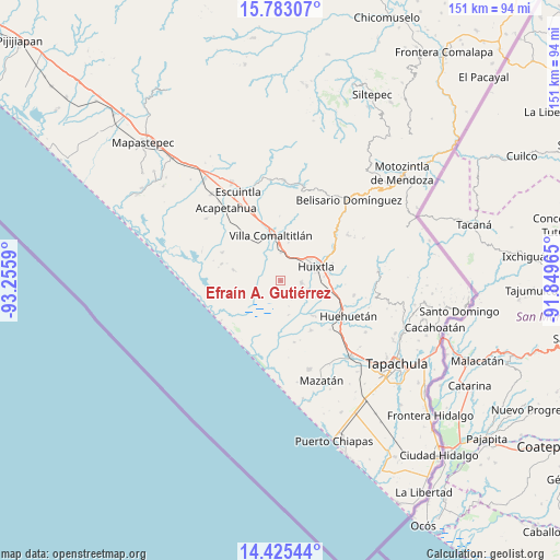
Efraín A. Gutiérrez GPS coordinates[2]
15° 6' 19.224" North, 92° 33' 9.972" West
| Map corner | latitude | longitude |
|---|---|---|
| Upper-left | 15.78307°, | -93.2559° |
| Center: | 15.10534°, | -92.55277° |
| Lower-right: | 14.42544°, | -91.84965° |
| Map W x H: | 151×151 km | = 93.8×93.8mi |
| max Lat: | 32.7° ⇑99.2% North |
| Efraín A. Gutiérrez: | 15.10534° |
| min Lat: | ⇓0.8% South 14.53588° |
| min Long | Efraín A. Guti | max Long |
| -117.105° | -92.55277° | -86.73105° |
| W 91.4%⇐ | ⇒8.6% E |
Elevation
Elevation of Efraín A. Gutiérrez is 20 m = 66 ft, and this is 1233.7 m = 4048 ft below average elevation for this country.
| Max E: |
3497 m = 11473 ft | 91.6% |
| Avg. | 1253.7 m = 4113 ft | |
| Efraín A. Gutiérrez | 20 m = 66 ft | |
Min E: |
-1 m = -3 ft | 8.4% |
See also: Mexico elevation on elevation.city.
Geographical zone
Efraín A. Gutiérrez is located in North Torrid zone (between Equator and Tropic of Cancer). Distance of this Northern Tropic circle is 926.4 km =575.6 mi to North.| Distance of | km | miles | from Efraín A. Gutiérrez |
|---|---|---|---|
| North Pole | 8327.5 | 5174.5 | to North |
| Arctic Circle | 5721.6 | 3555.2 | to North |
| Tropic Cancer | 926.4 | 575.6 | to North |
| Equator | 1679.6 | 1043.7 | to South |


Nearby cities:
15 places around Efraín A. Gutiérrez: (largest is in red/bold)
• Aquiles Serdán
10.1 km =6.3 mi,  54°
54°
• Cantón Playa Grande
3.9 km =2.4 mi,  73°
73°
• Cantón Rancho Nuevo
5.1 km =3.2 mi,  145°
145°
• Cantón Santa Cruz la Unión
9.9 km =6.2 mi,  332°
332°
• Cantón las Brisas
9.3 km =5.8 mi,  300°
300°
• Cantón las Delicias
5.7 km =3.5 mi,  93°
93°
• Colonia Obrera
5.9 km =3.7 mi,  97°
97°
• El Arenal
7.6 km =4.7 mi,  108°
108°
• Emiliano Zapata
3.8 km =2.4 mi,  321°
321°
• Francisco I. Madero
4 km =2.5 mi,  167°
167°
• Hidalgo
10.5 km =6.5 mi,  307°
307°
• Huixtla
10.2 km =6.3 mi, 68°
• La Unión
7.2 km =4.5 mi,  140°
140°
• Lázaro Cárdenas
7.6 km =4.7 mi,  0°
0°
• Nuevo Brasil
10.5 km =6.5 mi,  11°
11°
Sources, notices
• [Note1] Compared only with cities in Mexico existing in our database
• [Src1] Map data: © OpenStreetMap contributors (CC-BY-SA)
• [Src2] Other city data from geonames.org with taken over terms of usage.
• [Src3] Geographical zone / Annual Mean Temperature by Robert A. Rohde @ Wikipedia
