Vicente Guerrero geodata
Vicente Guerrero (Chiapas) is a populated place; located in Mexico in America/Mexico_City (GMT-6) time zone. With population of 834 people, there are 10487 cities with bigger population in this country. Compared to other cities in Mexico, 97.2% of cities are located further ↑North; 95.8% of cities are located further ←West and 57.8% of cities have higher elevation than Vicente Guerrero. Note1


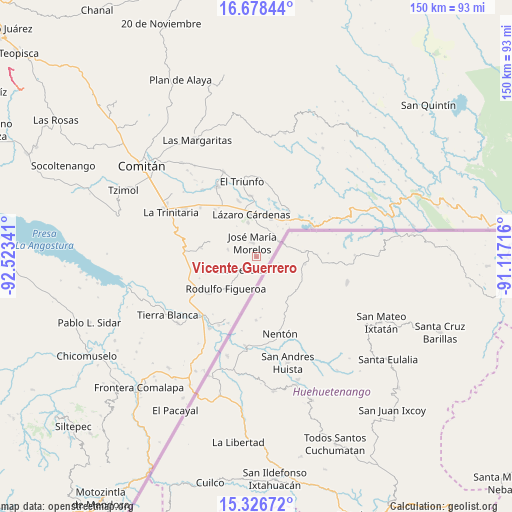
Vicente Guerrero GPS coordinates[2]
16° 0' 13.392" North, 91° 49' 13.008" West
| Map corner | latitude | longitude |
|---|---|---|
| Upper-left | 16.67844°, | -92.52341° |
| Center: | 16.00372°, | -91.82028° |
| Lower-right: | 15.32672°, | -91.11716° |
| Map W x H: | 150.3×150.3 km | = 93.4×93.4mi |
| max Lat: | 32.7° ⇑97.2% North |
| Vicente Guerrero: | 16.00372° |
| min Lat: | ⇓2.8% South 14.53588° |
| min Long | Vicente Guerrer | max Long |
| -117.105° | -91.82028° | -86.73105° |
| W 95.8%⇐ | ⇒4.2% E |
Elevation
Elevation of Vicente Guerrero is 1107 m = 3632 ft, and this is 146.7 m = 481 ft below average elevation for this country.
| Max E: |
3497 m = 11473 ft | 57.8% |
| Avg. | 1253.7 m = 4113 ft | |
| Vicente Guerrero | 1107 m = 3632 ft | |
Min E: |
-1 m = -3 ft | 42.2% |
See also: Mexico elevation on elevation.city.
Geographical zone
Vicente Guerrero is located in North Torrid zone (between Equator and Tropic of Cancer). Distance of this Northern Tropic circle is 826.5 km =513.6 mi to North.| Distance of | km | miles | from Vicente Guerrero |
|---|---|---|---|
| North Pole | 8227.6 | 5112.4 | to North |
| Arctic Circle | 5621.7 | 3493.2 | to North |
| Tropic Cancer | 826.5 | 513.6 | to North |
| Equator | 1779.4 | 1105.7 | to South |


Nearby cities:
15 places around Vicente Guerrero: (largest is in red/bold)
• Carmen Xhán
8.2 km =5.1 mi,  57°
57°
• Chihuahua
16.6 km =10.3 mi,  280°
280°
• El Porvenir Agrarista
18 km =11.2 mi,  354°
354°
• El Progreso
13.2 km =8.2 mi,  341°
341°
• José María Morelos
4.4 km =2.7 mi, 343°
• La Esperanza
17.3 km =10.7 mi, 342°
• La Gloria
16.1 km =10 mi,  254°
254°
• Las Delicias
6 km =3.7 mi,  230°
230°
• Lázaro Cárdenas
12.6 km =7.8 mi, 353°
• Miguel Hidalgo
12 km =7.5 mi,  21°
21°
• Ojo de Agua
18.4 km =11.4 mi, 21°
• Rodulfo Figueroa
12.9 km =8 mi,  223°
223°
• Unión Juárez
18.4 km =11.4 mi,  318°
318°
• Álvaro Obregón
10.4 km =6.5 mi, 346°
• Ángel Albino Corzo
8.6 km =5.3 mi, 284°
Sources, notices
• [Note1] Compared only with cities in Mexico existing in our database
• [Src1] Map data: © OpenStreetMap contributors (CC-BY-SA)
• [Src2] Other city data from geonames.org with taken over terms of usage.
• [Src3] Geographical zone / Annual Mean Temperature by Robert A. Rohde @ Wikipedia
